Nav Bar

About     ♦   Foraging     ♦   Backpacking     ♦   Trail Food    ♦   Wild@Home    ♦    Links    ♦   Demeter's Wild @ Home Store

Emergency Essentials/BePrepared

Appalachian Trail Day 27 - Hot Springs to Allen Gap - A Bear Closure and Laughing Heart Hostel ( Mile 275 to Mile 290)

 We are back on the trail!! It's actually been too long! Almost 11 months since we were last here.  We are thrilled and excited with getting back on the AT.  Since we last left the trail, I have been working non-stop.  I am a nurse and do travel contracts so I can spend more time with my husband, who works away from home. I try to keep in shape, but the best way to train for the trail is just to get on the trail and take it easy.  

We decided to go to Trail Days in Damascus, VA and then head down here.  We arrived at Trail Days on Friday afternoon.  Trail Days is always so much fun.  We camped next to a really fun group of people who brought drums and bongos and a big horn that I tried to blow.  It was too funny!  We danced barefoot in the mud around the bonfire after Miss Janet opened the festivities, and we browsed the vendor and food area.  The crowds were lighter than years past, but there was still thousands of people present. After a weekend of revelry, we were ready to head into some quiet wilderness, where the only wild things are those on four legs. 

I started calling around for parking last month, but I was struggling to find parking for the three weeks we will be gone for this section.  I called several hostels,  but even though I offered to pay, they didn't want to commit parking spaces for someone who wasn't staying with them, since parking is hard to come by during Trail Days.  Leaving my vehicle in a public spot isn't an option for me, since I've witnessed too many vehicle break-ins at trail heads.  Thankfully, in a moment of serendipity two weeks ago, GG was in Damascus for a trail race (she runs ultra-marathons) and was inquiring in a store about suggestions for parking, when a shopper offered for us to park at her house right in town!! The kindness of strangers never ceases to amaze me. 

We drove to the woman's house, only a couple blocks from the vendor area, and parked in front of her house. My truck is only a couple weeks old, so I'm hoping it will be in the same shape when we return.  There was a wicked storm with some tornado activity last week, and downed trees and branches are evident all around the town.  The house next to hers had a huge sycamore fall onto the deck. Hopefully all the branches have fallen...

I originally arranged a shuttle three weeks ago with a shuttle driver out of Hot Springs.  We agreed on the terms ($200 to be paid on pick-up) and the time.  I tried to follow up with him several times last week and he ghosted me.  I finally received a text YESTERDAY that he couldn't drive us.  AYFKM?! Thanks for waiting until the last minuted and then leave me hanging!  Where the hell am I going to find a shuttle to take us over one hundred miles in the next few hours.  Freaking out, I called around and was able to arrange a shuttle with Steve of Unicoi Shuttles.  This is no small feat on any weekend, but especially the weekend of Trail Days.  The majority of people on the trail try to get there for the party and then get transported back.  

Thankfully, Steve was much more dependable than the other guy, that I won't name because I'm feeling magnanimous.  Steve was very prompt, arriving just as we were finishing putting things away in the truck.  I changed into my hiking shoes and we loaded into his Subaru for the two hour drive to Hot Springs.  The ride passed quickly.  Steve was very knowledgable about the area and reassured us that he could pick us up along the trail if we had any difficulty.  He dropped us off and we checked into the hostel yesterday afternoon.  We spent a few hours outside watching younger hikers play frisbee and cooking dinner on the hostel-provided grill while we enjoyed a little cocktail in a coffee mug. 

We have a conundrum, as a rather large section of the trail is closed to camping due to recent aggressive bear activity.  Hiking through this area is allowed, but overnight camping is prohibited.  Not that we want to camp in an area with aggressive bears, anyway.  We can hike 6 miles to Tanyard Gap and stealth camp, then 14 miles the next day from Tanyard Gap to the next open camping site at Little Laurel shelter.  We would have to camp near a road, which we are not fond of. Plus, the bears could still range in that area.


We choose Plan B, which is to slack pack 15 miles to Allen Gap, then get picked up by a shuttle in the evening and come back here.  This means we only have to carry minimal supplies for a day hike, leaving our sleeping gear and shelters here.  I absolutely know I am not in shape for a 15 mile hike with over FOUR THOUSAND FEET of elevation gain. Remember, I live at 7 feet above mean tide.  I am a flatlander who can't get any flatter.  I am going to suffer for sure.  GG has 15 years on me, but she has been marathon training.  

I call Kate, the shuttle driver that originally drove us from Hot Springs to Dick Creek's Gap last year. She is booked and unable to drive us back to town at the end of our hike but gives me another number.  I call and line up a shuttle to pick us up at Allen Gap at 5 p.m. 

We went to bed early so we could be refreshed for our big day tomorrow. GG slept on the futon in our room while I take the bed.  I can't sleep in a bed smaller than a king with anyone else.  Weird, I know, but I won't sleep if anything touches me. 

We get up early and pull on our hiking gear.  It's chilly outside and we have on our down coats over our hiking clothes, but it's supposed to be in the 60's today with some clouds later today.  We are only carrying some water and snacks and rain gear.   I decide to leave my heavier layers at the room to shed pack weight, since the weather outlook is decent.  


We take a quick picture and head down the hill from the hostel, into the town of Hot Springs.  The sun is just starting to peek over the ridge in front of us, which we will be climbing shortly.  The day is cool but not uncomfortable.  We walk through town and then start the climb up the ridge, shedding layers frequently.  We know today is going to be a rough reintroduction to the trail, and I am ready!

Walking into Hot Springs from Laughing Heart

While hiking up the ridge on the other side of Hot Springs, we stop frequently to take in the pretty view of the river below and the town beyond.  We hike by a gentleman who is packing up his tent.  He has an adorable brown Aussie Shepard named Jasper.  We exchange pleasantries and keep trucking upward. 

The enthusiasm for being back on the trail carried me for the first five or six miles, but as we hiked to the top of the ridge, the sun went behind the clouds, the wind really picked up and the temps plummeted.  I went from feeling elated to feeling absolutely beat.  

The climb never seems to stop from Hot Springs to Allen Gap


An idyllic spring forest


After 11 miles, we stop for a break from the wind inside the Spring Mountain Shelter.  We collected water from the spring down the hill from the shelter, leaving our packs inside as usual.  I was laying inside on the dirty floor with my legs elevated on the side of the shelter wall in order to get some of the swelling out of my lower legs, and my skirt hiked up to my butt, when a through hiking couple showed up. Thankfully I wear men's wool boxers underneath for modesty.  I didn't have the energy to get up, but eventually I did just to jump around and get some warmth to my bare legs. I am really regretting not bringing some extra layers right now!  


The couple introduces themselves as Ragnar and Mochila.  They tell us that word on the trail was that a hiker recently dropped his backpack at the shelter while he went to filter water (just like we did), and when he came back up the hill from the spring, he witnessed a bear making off with his entire backpack!  Thus, the bear closure.  This information prompts us to hurriedly continue on the trail. We have done most of the elevation gain for the day, so the next four miles is thankfully downhill. 
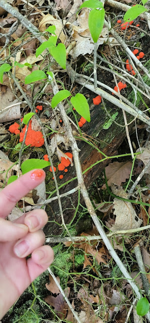

A really cool slime fungus

We arrive at Allen Gap 15 minutes after we were supposed to meet the shuttle.  Another hiker is heading back to town with us. Within an hour I am in a hot shower and popping 800mg of ibuprofen.  We are so tired we decide to eat one of our trail dinners instead of going into town.  

I sit down at the picnic table across from a woman who is going through her food bag.  She obviously just resupplied in town, as she has a lot of food spread on the picnic table between us.  We make simple conversation, and I discover she is a through hiker named Kodiak.  Her name the result of the cute little stuffed bear she carries, which was a gift from her niece.  She takes pictures with it and sends the pics to her family.  

GG joins us and Kodiak tells us a harrowing story of the night before, when she was camped in a clearing next to the road with two other people at Allen Gap.  A vehicle drove up and at least two people got out and flashed their lights into and around the three tents, at one point even scratched on her tent!! EEK!!  She tried sending an SOS via her Spot device but was unsuccessful.  She said it went on for almost five hours! Thankfully, the jerks ended up leaving without incident, but she was very terrified, nonetheless.  THIS is why we never camp anywhere near a road.  Too easy for bad apples to spoil the hike for decent people. 

Kodiak is also getting a ride to Allen Gap tomorrow, so we decide to try to ride together to split the cost. 

The day was grueling! But we made it!  And tomorrow will be easier.  I know each day will get better, but it stinks to need to build up my trail legs every time we come back to the trail. We head to bed early.  

Today's stats: 15 miles, 4400' of some crazy climbing my legs aren't in shape for!!

Trail Stats:  290 miles, 70k feet total gain


Appalachian Trail Day 26 - Roaring Fork Shelter to Hot Springs - TTFN (Mile 257- Mile 275)

I wake gradually as full dark begins to give way to daybreak. I sleep with a buff over my eyes, and when I take it off I can see the sun is still below the horizon, but I can feel the forest starting to wake.  The hoots of owls give way to slow chirps of songbirds in the trees above.  I stretch languidly in my hammock, slowly increasing the blood flow to my muscles.  Thankfully, the aches are pretty much gone in the mornings and I am feeling stronger by the day.  

I peek out from under my tarp to see GG is up and at 'em in usual fashion.  She is mostly packed up and getting ready to enjoy her coffee and palaver at the shelter. I am so happy to be back in the middle of the woods with my hammock.   I wish I could lay here for hours, but we have to hike the longest day so far on the trail.  Our next stop is Hot Springs, NC, where my car is parked. Today we are heading home. 

I am super excited to get home after almost three full weeks of hiking, but I am also reticent to leave the trail.  I am definitely getting stronger and maybe a little faster.  Hard to tell with all the loitering I like to do.  It's a shame to leave when we are starting to be able to hit bigger mile days. But, I have a husband to get home to and a job to start.  Better get packing!

I pack carelessly, since it doesn't matter what gets dirty or if something damp is packed next to something that needs to remain dry.  I will pull it all out and clean it when I get home anyway.  There is a chance for some rain in the forecast, so I leave my food and rain gear on the top of the main compartment.  

Today we have 3200' of gain over the next 18 miles, divided between three climbs.  We also have almost six thousand feet of knee-pounding descent!  Thankfully, my pack is lighter because I don't have a lot of water or food weight.  Water is abundant along this section, so I am carrying very little in my pack.  I also planned my food for this section fairly well, so I have just enough food for today in my food bag.  Or maybe it feels lighter because I am getting fit.  

We get to Lemon Gap fairly quickly, as the hike here was mostly downhill.  I have no idea why it's called Lemon Gap.  I can't find any info on the internet.   The weather is damp and the Big Green Tunnel is living up to its name. 


The rest of the day passes unremarkably.  We hike over Bluff Mountain, then down, down, down, to Hot Springs.  I take some time to drink a lot of water at the Deer Park Shelter area.  There is a nice little stream with lots of campsites sprinkled throughout the surrounding woods.  GG is a little ways ahead, so I need to turn on some speed so she doesn't have to wait for me at the car.  

I can hear the town before I can see it.  The sound of cars slowly increases as I descend the last half-mile to town.  I can see the forest parking lot where I left my car almost three weeks ago.  I always hold my breath when I return to my car after a hiking trip, even when it's only a couple nights.  Car break-ins are prevalent at overnight hiker parking at any trailhead, but the lot is right behind Laughing Heart Hostel, so I am certain it will be unmolested. 

At the turn off to the lot, I see GG waiting with her backpack off.  She waited for me so we could complete this section together!!  We walk the 100' to the car together.  We are elated from completing this section without any injury or problems.  We just hiked 206 miles of trail over 19 days.  We are feeling badass!  And hungry!  The car is intact as well, so everything is great.

We check in to the Laughing Heart Hostel, where I booked us a room for the night.  We shower and change into fresh clothes we left in the car.  We go to Spring Creek Tavern, a restaurant on the river less than a mile from the hostel.  There are lots of hikers in the restaurant.  We order craft brews and I get fried pickles and loaded nachos, which is my favorite town meal.  GG has never had nachos before!!  We finish up and head back to the hostel for a last bit of fellowship with hikers until the sun sets.  We head back home in the morning. 

This part of our adventure has come to a close, but I will continue our journey as if we never left the trail.  For continuity, the entry for day 27 will follow this one, whenever we return - whether it is next month or next year, so keep reading as we continue on the trail. TTFN.


Todays stats: 17.6 miles, 3200' elevation gain (5800' loss)

Section stats: 205 miles, 58K elevation gain

Trail stats: 275 miles, 66k of elevation gain (more than two Mt. Everests!)

Appalachian Trail Day 25 - Standing Bear Farm to Roaring Fork Shelter & Max Patch! (Mile 241.8 - Mile 257.3)

 I loved my stay at Standing Bear Farm.  I have to admit, there were some bad reviews on the Far Out app (fyi the app is the best way to navigate the trail), and we had some misgivings about staying there, with some reports of wild kids running about and loud, noisy party types.  Yes, there are children living on the farm, but they played like any children fortunate enough to live in the country, and they were well behaved and polite when interacting with the guests.  There was the normal amount of noise, which by Appalachian Trail standards, isn't a lot.  Everyone in our area was asleep by 9:30 at the latest.  

I wake and break down camp and head over to the kitchen area to sit near a smoldering fire.  I perch on a cut log and chat with other hikers.  There are a lot (maybe 25) people, with five or six sitting around the fire, some hikers clearing out of the bunkhouse, and others making coffee and breakfast in the kitchen cabin.  I go to the house to settle up my bill, which isn't much because I only had to pay for a campsite and two beers.  

This is our last full day on the trail for this section, and I'm stretching it out as long as possible.  This experience has been amazing, and the thought of leaving for a while is bittersweet. I am excited to go home and see my family.  I miss my bed.  I would say I miss creature comforts like daily showers and a never-ending supply of clean clothes, but I can live without them.  Living out here teaches one the difference between needs and wants.  A backpacking, nomadic lifestyle is the bottom rung of Maslow's Hierarchy.  We have hiked 18 days straight without a break longer than a few hours. 

We have reached another milestone of our journey.  Today I am thrilled to be moving on to the next section of the Appalachian Trail guide on the Far Out App!  I'm sure most people would be like "so what?," but to me it's another psychological accomplishment.  The trail is so long that the app is split into sections.  I purchased the entire trail at once for a discounted rate, and download the section I am currently hiking so I can access the information when I don't have cell service.  I am now on the "Northern TN & NC" section (232 miles), and can delete the "Georgia thru Great Smoky Mountain National Park" section (242 miles).  This may seem like like celebrating the minutiae, but it's wonderful to see progress!


We head up the trail around 9 am.  This is going to be one hell of a climbing day.  Straight out of the gate, we have a 2600' climb this morning, but at least it's over five miles.  Thankfully, the day is warm but not uncomfortable, and lots of clouds are moving overhead, shielding me from the hot sun. 

GG and I frequently hike alone during the day and tend to meet up when whomever is in the lead (usually GG) decides to stop, whether it's at a snack break, or a special view, or at lunch.  I tend to lag behind because I love to identify plants along the route. I have several plant identification books downloaded to my phone, and they are a little challenging to flip through on a small device.   

Oyster mushrooms (Pleurotus ostreatus)

I get to the top of Snowbird peak around lunchtime.  The peak, like so many in the Smokies, is a bald, without any trees.  The trail crosses a gravel forest road and I get a glimpse of a really strange looking satellite dish surrounded by a fence and lots of "keep out" signs.  I stop to walk around the facility and continue on down the trail. 


The remainder of the day is rather uneventful.  I have hiked five miles, all uphill to this point, and now I have a 1500' descent over the next three miles to the next shelter, and another 10 miles until we stop for the night.  Thankfully, there are several beautiful views to be had today.


I get to the highlight of the day: a huge open bald named Max Patch, which is Appalachian Trail famous.  All day I have had my left foot in Tennessee and my right foot in North Carolina.  The mountain is known for it's amazing 360 -degree views, and thankfully the weather allows me to enjoy the spectacular views from the top. I would love to stay up here and watch the sunset. I bet it's amazing. While I am at the top, I get a text from GG saying she is heading down to the next shelter, so I guess I had better go as well.  At least I get to continue to enjoy some views on the hike down.  The trail is a combination horse trail and forest road, thick with ferns and moss covered birch.  

GG is set up at the shelter when I arrive.  I quickly set up and we are off to bed by 9 p.m.  Our last night on the trail for a while.  Good night!


Todays stats:  15 miles, 5200' elevation gain
Section stats:  178 miles, 46k elevation gain
Trail stats:  257 miles, 63k elevation gain


Appalachian Trail Day 24 - Cosby Knob Shelter to Standing Bear Farm - Rattlesnake & Leaving SMNP (Mile 231.4 to 241.8)

 We wake bright and early, full of excitement.  Today we are leaving SMNP and heading to Standing Bear Farm.  The thought of a hot shower, clean clothes, and some treats can really lift the spirits.  At breakfast, I tell the other hikers about the firefly display the evening before.  Apparently I was the only witness to the show.  We filter water and load our packs and hit the trail as the sun peeks through the trees.  

Reishi mushrooms


Today is really light on the inclines (only 1300'), but going to be brutal on our knees.  We have to descend 4400' downhill to get to our next stop.  I will be hitting the Vitamin I (ibuprofen) today for sure.


The heat is rising as we go over Mt. Cammerer at 5,000' elevation, this is the last mountain to climb in SMNP, and the last time we will get above 5,000 feet of elevation for another 85 miles.  We skip the side trail to Mt Cammerer, which I will regret, as it's supposed to be "one of the most worthwhile side trips on the A.T." as I read later in my Far Out app. 

We start our long, 8-mile descent, and have gorgeous views on the way down.  A short way down, I am hiking by myself when I almost stepped on a rattlesnake!!  The snake was doing what snakes do, and sunning itself in a little patch of sunlight right in the middle of the trail.  My adrenaline was jumping as I watched a really pissed off juvenile shake it's tail for what seemed like a very long time, but in reality was a few minutes. Juveniles are more dangerous than adults because they have less control over their venom release and will dump it all in one bite. I am in the lead of the hikers coming off the mountain, so I wait for GG and a big group of hikers to come down so no one accidentally treads on the snake.  The video is below. Hopefully I uploaded it correctly :-)


After a couple snack stops, we pass Davenport Gap shelter, which is downhill and to the left of the trail. We can just make out the roof from this angle. This shelter is renowned for the most bear sightings of any shelter in SMNP.  The bears are so bad, in fact, that food hangs are prohibited outside of the shelter.  The food must remain in the shelter, where a chain link fence surrounds the shelter in order to protect campers from aggressive bear incursions.   Talk about feeling like a fish in a fishbowl! 

One mile after the shelter we see the sign and permit box marking the northern boundary of SMNP!  What an accomplishment!  The Smokies are not easy to hike whatsoever, but the park has been so beautiful.  The pristine scenery and all the wildlife, big and small, have made it quite an adventure.  We place our permits in the box and continue on down the trail .


Placing my permit in the box leaving SMNP


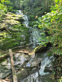
A pretty waterfall

We cross over a creek at the base of a decent sized waterfall.  Just around the corner we can make out a road at the bottom of some steps.  A car is waiting with the lift gate open, and some people are milling about.  Could this be trail magic!?  It is!! A wonderful couple is picking up their section-hiking daughter and kindly brought some treats.  I take an apple and also accept a banana when they encourage me to take all I want.  Fresh fruits and veggies are my most craved foods on the trail. I wash it down with an ice-cold Powerade. Even though we hiked mostly downhill, the temps are in the mid-eighties and I need some electrolytes.

Trail Magic

We give our thanks and continue on.  Less than 2 miles to go for the day! The Pigeon River is visible from the trail magic.  Walking over the bridge, we are greeted by the sight of several rafts paddling down the river.  The paddlers are whooping and waving as they cross under the bridge.  I would love to take a dip in the cool water, but we're so close to the next stop, I power on. 

Rafters on the Pigeon River

We walk beneath I-40 and just like that we are off the road and back on a real trail.  Almost immediately,  my forward progress is stopped by a fallen tree blocking the trail.  The tree isn't big, however the branches in all directions will make this difficult.  The topography is such that we can't go up or downhill to walk around it.  I take off my pack and somehow make it through the tree.  GG needs some help, as she has so many things attached to her pack that she has more things to get stuck on tree limbs. 


Thirty minutes later we see a sign for Standing Bear Farm and veer off the trail onto a road which runs parallel.  The farm is a collection of buildings that resembles a small village spread out amongst the trees.  There is quite a lot of activity, with hikers walking about and children laughing and playing.  We are directed to a house to check in.  It's warm enough at night that we plan to camp rather than sleep in an unconditioned bunkhouse. The woman running the farm points us toward the camping area to the right of the house.  There is a camp store in one building, a kitchen cabin with attached laundry, a bunkhouse, and a separate bath house. A lovely stream runs between the property and the gravel road.  We find our camping spot and start setting up next to a stand alone covered porch with a swing. 


The camp kitchen and laundry


A rental cabin straddling the stream

My shoes need some airing out


We are given a piece of paper and pen to write down our purchases.  Many hostels use an honor system and take cash or have a Venmo QR code to transfer money.  The shower and laundry is included.  We still have food from Newfound Gap, so the only thing I purchase is a couple of hard ciders.  I put them in the creek next to my camp while I wash in one of the coolest showers on the trail.  The shower is inside a cabin and made of tile mosaic.  With the windows open and the breeze blowing I feel like I'm outside.  


I love this shower!


After shower, the next town chore is laundry.  The laundry room consists of one electric dryer.  There is an old-fashioned washboard in the sink.  I guess we're doing this the old-fashioned way, then. We fill the sink with soapy water and start agitating our clothes with our hands.  The water quickly gets clouded with dirt, so it takes me three or four washings and wringings before the clothes are clean enough for the dryer.  


GG and I sit on the porch for dinner.  Children are playing and painting with the help of a hiker. Another hiker pulls out a guitar and we have a sing along.  This is a fun and relaxing way to celebrate getting out of SMNP.   We have hiked 175 miles without a full day off,  but these occasional respites from the trail keep us going.  The trail is so much more than a hiking and camping adventure and deprivation.  The Appalachian Trail experience is really about community and learning to slow down to enjoy the little things in life that bring joy and peace. 


Todays Stats:  10.4 miles, 1300' elevation gain

Section Stats:  163 miles, 41k elevation gain

Trail Stats:  241 miles, 58k elevation gain


Appalachian Trail Day 23 - Peck's Corner Shelter to Cosby Knob Shelter + Fireflies! (Mile 218.5 to Mile 231.4)

I wake with the sunrise and see many other hikers are already up.  GG has already broken camp, as usual.  Our typical morning routine is for her to get up 30 minutes to one hour before me so she can have a leisurely breakfast and some fellowship with other hikers.  I, on the other hand, like to laze in my hammock and get a little more sleep, then pack quickly, stretch, and hang out with the other hikers in front of the shelter for a few minutes before hiking and snacking on the trail.  Some mornings I am stiff as a board from the previous days' efforts, but this morning isn't too bad.  Yay for the trail legs! I think we can start hitting slightly higher mileage without too much additional effort. 

An hour later, we are chugging back up the hill toward the Appalachian Trail.  Unfortunately the almost half-mile hike doesn't count in the days' mileage.  We call these "bonus miles."  In addition to the mileage walked on the AT daily, hikers can easily rack up an extra 1-3 bonus miles per day.  While many shelters and water sources are literally on the trail, many more are not.  Shelters and water are frequently a quarter mile off trail.   Very often, once we get to camp, we have to take multiple side trails to water, bear boxes and bear cables, and the privy.  Not to mention the bonus miles one may need to take in order to find a private spot to water the leaves throughout the day.  I need to be more conscientous of my bonus miles and practice conservation of movement when I am at camp. 

Once we get to the AT, our hearts are pumping and the day is warming up.  I usually keep some layers on until the sun gets high enough to warm the air, but the hike today was more than enough to get us warmed up quickly. My pack is fairly light today, as I have little food and water to carry.  I have one days' food for today, with some snacks for tomorrow morning, as we will resupply tomorrow afternoon. I'm carrying just one liter of water, since the next shelter is five miles a way, with water near the shelter. 

A hazy morning


We play leapfrog with a group of four men section hiking GMNP, two of which have never backpacked before.  They left the shelter before us, but GG and I pass two of them before we get to the next stop. Their packs are huge, like 65 liters stuffed to the brim, as well as tents and stuff sacks attached to the outside of the pack.  

Have I mentioned how much I hate it when people strap things to the outside of the pack?  I don't know why I let it get to me.  After all, I'm not the one carrying all that stuff.  I just think that one should carry what will fit inside of the pack, or get a bigger pack.  Nothing screams inexperienced backpacker more than crud swinging off a pack.  I really feel for these guys, because they will have a miserable experience by carrying a lot of unnecessary things, in a backpack that is way too big, especially in these mild conditions.  This is why so many people are one and done with backpacking.  

We arrive at Tri-Corner Knob Shelter (elevation 5887') in time for an early lunch.  We hiked over three small hills, gaining 1200' over the last five miles.  The sun is dappling the small clearing beside the shelter, and I take all my stuff out of my pack and spread it around a rocky spot next to the shelter to air out while we eat and filter water from the stream that runs right in front of the shelter.  The air this morning was very humid and my sleeping gear was damp when I packed it up.  There are a lot of hikers from this morning stopping for lunch.  We squeeze around the one picnic table, and more hikers are perched on the sleeping platform inside the shelter. 


My usual lunch is a pouch of tuna or salmon mixed with a small pack of mayo and a pack of relish on a high fiber tortilla.  My hiker hunger is starting to kick in, and I also eat some Cheetos and a protein bar, as well as some jerky that one of the other hikers offer the group.  Meal time is a great way to get rid of some extra food!  After a very leisurely hour-long lunch, I reluctantly stuff everything back into my pack.  I would love to spend some time laying in the warm sun in the grassy clearing, but we have miles and miles before we sleep!

Azaleas in bloom


The trail climbs straight up from Tri-Corner Knob Shelter,  but the rest of the way is downhill for the next 8 miles.  The sun is shining brightly and I have to stop and apply sunscreen.  The AT is frequently referred to as the "big green tunnel" because most of the trail is covered by tall tree foliage, dotted with bare patches. I don't bother carrying sunglasses because they aren't necessary for 90% of the trail.  Today is an exception, and I would love a pair today. The sun is on my left, west of the ridge, and I am sweating buckets as I descend a section of trail that is covered in small rocks, almost scree.  I'm making good time as I pass one of the four backpackers.  He looks worn out and downright downtrodden. "Don't give up, we are almost there!"  I say as I pass him.  


Less than an hour later I see GG waiting at the sign for Cosby Knob Shelter.  Since getting lost a few days back, she has been staying closer to me when we hike, but when she wants to stretch her legs and go ahead, she waits for me at trail and road crossings.  The side trail to the shelter is very short, and the shelter is just to our right.  No big trek down to the shelter today!  The water is a spring literally steps from the shelter.  No bonus miles for water!
A weird stone that looks like a knife


The first thing I do is drop my pack, change to my camp shoes,  and scope out the area around the shelter for a suitable hammock spot.  Most of the time, this is going to be in the area set aside for tents, because the underbrush is cleared out.   I have the benefit of not needing a level site - I just need two trees that are the right distance apart.  The distance is a minimum of 13 feet and up to 20 feet. That's the maximum line I have on my tarp and hammock.  

I find a good spot and set up near GG.  More people are arriving as we set up and soon there are easily over 20 people spread between the camping area and in the shelter, with more coming in the waning light.   We talk with other campers for an hour while preparing dinner.  The excitement of heading out of the park is palpable.  Getting out of SMNP is another big accomplishment to check off our list.  We are looking forward to looser camping regulations, as well as less congestion on the trail.  Additionally, while the bears don't magically disappear once we leave the Smokies, they tend to be a little less visible because they are hunted outside of the park, making them more wary of people. 

Everyone is drifting off to sleep and I am reading when I start noticing little flickers of light dotting the area around the tents.  Fireflies!  When we were at Fontana Village, Croft mentioned she really wanted to see fireflies, as she has never seen them before.  I grew up in Pennsylvania and the midwest, playing with fireflies in the summer.  They were so prolific and I never thought twice about their presence.  A very small part of my life that I now know I have taken for granted, like countless other things.  

The twinkling of the lights intensifies, as more of the insects join the party. I wish Croft were here to see the display.  There are so many things I am experiencing I wish I could share with friends and loved ones. I am so happy to be out here, taking in what nature is offering.  I hope I could bottle this entire experience.  

Good Night!

Todays stats: 13 miles; 2700' elevation gain

Section stats: 162 miles; 40,000' elevation gain

Trail Stats: 231 miles, 57k feet elevation gain