Nav Bar

About     ♦   Foraging     ♦   Backpacking     ♦   Trail Food    ♦   Wild@Home    ♦    Links    ♦   Demeter's Wild @ Home Store

Emergency Essentials/BePrepared

Appalachian Trail Day Day 18 - Fontana Dam to Mollies Ridge Shelter - Smokies and the Bear! (mile 164.3 to mile 177.7)

 Our stay at the Fontana Lodge is heavenly but way too short.  Last night we returned to the hotel around 10pm. I packed and enjoyed a glass of wine, charged my electronics, cleaned up my email, then to bed around 1 am.  

I am slumbering in my cozy bed when Kelly and Penny alternate knocking on my door each hour starting at 7am. By the third time, at 9am, I give up on sleeping any further. I half-heartedly shove my few belongings into my pack.  Kelly drives Penny, Gordon, and me back to the trail and we say our goodbyes, but we know we will see her again very soon. At least we hope so, not only because we enjoy her company, but Kelly also has half of our food for the Smokies! 

Being the angel she is, Kelly has really gone over and above our new-found friendship, offering to meet us with half our food for the Smokies at Newfound Gap in Smoky Mountain National Park (SMNP).  Instead of carrying six to seven days of food, we only need to carry three. This will save each of us at least five pounds. This may not seem like a lot to most people, but to most backpackers this is huge!  These five pounds is an extra 25% of my overall pack weight. 

Appalachian Trail Day 17 - Brown Fork Gap Shelter to Fontana Dam - Mud, Downed Trees, and Beer! (mile 152.9 to mile 164.3)

We awoke rested from 18 hours in the shelter. Everything is damp and smells awful!  The only dry clothes are the ones we slept in last night.  Today promises to be hot and muggy so I dress in my wet t-shirt and socks, but at least I have dry boxers on!  Most of my hiking clothes are quick-drying lightweight wool.  

The rain has stopped, but the leaves above the trail are laden with water. Every time the wind blows we get showered!  

Shortly down the trail, Just Gordon and I encounter a large tree downed by the storm.  I take off my pack and throw it over the deadfall. The trail is extremely narrow where rain washed out big holes on the downhill side. We start clearing the remaining small ledge of trail for the hikers coming up behind us.  Just Gordon elects to keep his pack on. While he is trying to lever a huge branch to the side, he literally somersaults down the hill!  I am saying "Stop, Gordon, stop!" Like he can hear me!! Thankfully the tree arrests his descent before he goes any further. 


Appalachian Trail Brown Fork Shelter to Fontana
Just Gordon wrestled with the tree


Six miles later we arrive at Cable Gap Shelter.  Smiles and some other hikers stayed here last night. While there is no hole in the floor, the shelter leaked all over them in the storm last night. Maybe we lucked out with the gross shelter after all!

Appalachian Trail Brown Fork Shelter to Fontana
Cable Gap Shelter

We have 5 miles until Fontana Dam, and a decent uphill.  If we hurry, we can be checked in and doing laundry and shower by 4 pm! 


Appalachian Trail Brown Fork Shelter to Fontana

Appalachian Trail Brown Fork Shelter to Fontana

Appalachian Trail Brown Fork Shelter to Fontana

We have hiked for 8 days straight without one full day off.  The lack of rest is really wearing on us. On the other hand, our bodies are adapting to the trail. Now, a couple of thousand feet is not a big deal - we are hiking faster without as many rest stops.  We arrive at Fontana Dam and Gordon called for a shuttle. We are wet and stinky!  The Fontana Lodge van arrives and the driver is a friendly former thru hiker. We check in and explode our packs all over the rooms. I elected to have my own room and Penny and Kelly are next door. 


The afternoon is anything but restful. The laundry facility is a half mile down the hill. We grab a light lunch, then shower and finish laundry. We meet up with other hikers. Mike, Bill, and Croft are going to zero here tomorrow. They are exhausted from the rain yesterday. Mike's tent collapsed in the storm and his sleeping bag and clothes got drenched.  Bill picked up a stomach bug at the NOC and needs to recover. Croft said all her stuff was soaked and she is worn out.  

Heavy rain is forecast for tomorrow night and all of the following day, so they decide to hunker down here for a couple days. I am super envious, but don't want to spend time in town when we still have so many miles to hike.  We have hiked almost 100 miles so far this section, but still have another 100 miles to get back to the car.

We finish dinner at 8:30 pm, but still need to go to the grocery store and pick up our resupply boxes from Hike Inn Hostel. They were booked for the rest of the week. Picking up our resupply boxes is  proving to be a challenge, since we didn't stay at the hostels as we originally planned. The hostel is 30 minutes away. Fortunately Kelly has her car here. She is finishing her section and already hiked the Smokies, so we will say goodbye in the morning :-(

Appalachian Trail Brown Fork Shelter to Fontana

Todays Stats:

Highest Elevation Today:

Section Stats:

Trail Stats: 

Appalachian Trail Day 16 - Sassafras Gap Shelter to Brown Fork Gap Shelter - Stuck in a Wood Box (mile 143.8 to mile 152.9)

 The biggest concern about shelter sleeping is the mice. The reports of nocturnal activity of mice walking over one's face and the occasional mouse in a sleeping bag is enough for many hikers to prefer camping outside the shelter.  Unfortunately, tenting isn't a guarantee some gear won't get messed with: a few years ago I was at a shelter in Shenandoah when a mouse chewed through a tent in the middle of the night. The intruder ended up squashed by a boot in the tent.  Chipmunks crawled into my backpack in Vermont, and in West Virginia a mouse chewed through an outer pocket of my backpack one night and on another occasion chewed through my food bag and left droppings in my oatmeal. 

Last night was a first for us!  GG and I accomplished the monumental endeavor of sleeping in an actual shelter ALL NIGHT!  To be honest, I didn't have the best night of sleep, being wakened by snores (even with my super duper purple earplugs), 10 hikers getting up to use the facilities in the middle of the night, and the occasional escape of wind from the esophagus or the other end... But no mice!! And we are relatively dry.  Even in the shelter everything is damp from the humidity.

We woke in the pouring rain, walked in the woods in the rain, walked up Cheoah Bald in the rain, and arrived at the next shelter around 2pm during a deluge. The highlight of my day is trail magic left by an angel: a big bag of huge apples left at Stecoah Gap.  We each take one, even though I could have eaten all of them. To the church who left this here, we really appreciated this!  Thank you so much :-)

I did not take any pictures during the hike today because I didn't want my phone to drown.

Brown Fork Gap Shelter is the smallest shelter we see on the trail. Most of the other shelters fit 6 or 12 people. This shelter is advertised as six, yet most of the space is taken up by our sleeping pads - a huge gap in the floor with plywood "gangplanks" that can be retracted to keep four legged visitors out of the shelter removes a lot of usable space.  A comment on the "Far Out" app we all use states the design is to prevent porcupines from coming in and destroying the wood structure.  The odor wafting from the gap is evidence that past hikers have used the space for a latrine. 


Brown Fork Gap Shelter, Appalachian Trail
A crowded and soggy bunch

We don't have enough room for 6 of us and all our stuff on the floor, so we get very creative at hanging our packs on the mouse hangers with all our gear hanging off every nook and cranny of the packs. We are drenched and cold. Shivering, we change into our night clothes and snuggle into our down quilts to warm up.  It's 3 pm and going to be a long afternoon! I'm not a day sleeper and read a Stephen King book on my phone and the sound of light snoring combined with the loud plinking of rain on the tin roof is calming. 

Brown Fork Gap Shelter, Appalachian Trail
Croft in her tent outside the shelter

Todays stats: 9 miles, 2313' elevation gain

Highest elevation:  Cheoah Bald at 5052'

Section Stats: 83 miles, 20,056' elevation gain

Trail Stats: 152.9 miles, 36,755' elevation gain

Appalachian Trail Day 15 - NOC to Sassafras Gap Shelter - Uphill to a Thunderstorm to (mile 136.7 to mile 143.8)

To say we lucked out with the weather the last 8 days is the understatement of the century. We hit the weather jackpot so far.  Unfortunately, our luck is running out today. Heavy rain is forecast for tonight and all day tomorrow, possibly through tomorrow night as well. Guess we gotta make hay while the sun shines!  

We leave the NOC. I am reluctant and dragging, the norm for me in the morning.  Penny and Karma are up and packing well before me, but I have less stuff and pack faster in general, so we are ready about the same time. We skip a real breakfast in the restaurant in order to hit the trail earlier, however hit our last toilet for the next couple days. 

Our hike today is 4000' up to Cheoah Bald.  This is one of those annoying sections that jaunt due west, adding miles to the overall AT but no real progress north. There is a shelter just short of the the top of the mountain,in 7 miles, at Sassafras Gap.  

NOC to Sassafras Gap
Looking Down on NOC

We hike up for what seems like forever. Humpty Dumpty hikes with us for a while. He is in his 70's and passes us on the uphill.  I blame it on my full stomach, not my lack of physical prowess :-) We leapfrog down the trail, discussing the coming thunderstorms.  Karma, GG, and I pause for a snack after 5 miles.  A couple with large packs stop to chat with us -  they are finishing a section hike at Fontana Gap and he is positively melting in the afternoon sunshine.  A young woman crests the hill shortly after and introduces herself as Croft. She is a mom of three, with an absolute angel of a husband who is at home with the kids.  

We get to Sassafras Gap Shelter, a very short down from the ridge. Just Gordon is here, as is Humpty Dumpty, Green, and Smiles!  Croft arrives shortly after. We take off our packs to snack and discuss the plan. The next shelter is another 9 miles after Sassafras Gap. Today is hot, but tomorrow will be a slog in pouring rain. I vote to continue the nine miles and get to the next shelter late, rather than hike in a downpour on the ridge. 

Then we hear the rumble of thunder and the rain falls. I am outvoted and this is our home for the night. At least this is a nice 12 person shelter with a nearby privy and a piped spring very close to the shelter.  The rain is sporadic until dusk, then Mother Nature opens the floodgates.  A lot of hikers were already asleep in the shelter, so I went to the stinky privy to talk on the phone with my better half. 

Sassafras Gap Shelter

Todays Stats: 7 miles, 3200' elevation gain

Section Stats: 74 miles, 17k' elevation gain

Trail Stats: 142 miles, 33k elevation gain

Appalachian Trail Day 14 - Wesser Bald to NOC - Nirvana in North Carolina (mile 131 to mile 136.7)

Life on the trail strips away all the "normalcy" of the modern world. Without the intrusions of TV screens and artificial light, our circadian rhythms have adjusted to the natural world around us. Mother Nature has a volume knob she progressively turns to zero as the sky darkens, and slowly increases the volume again with the next morning. Similarly, hikers go to sleep when it gets dark and wake up with the sunrise.  Just another critter in the woods...

Wesser Bald Shelter, Appalachian Trail
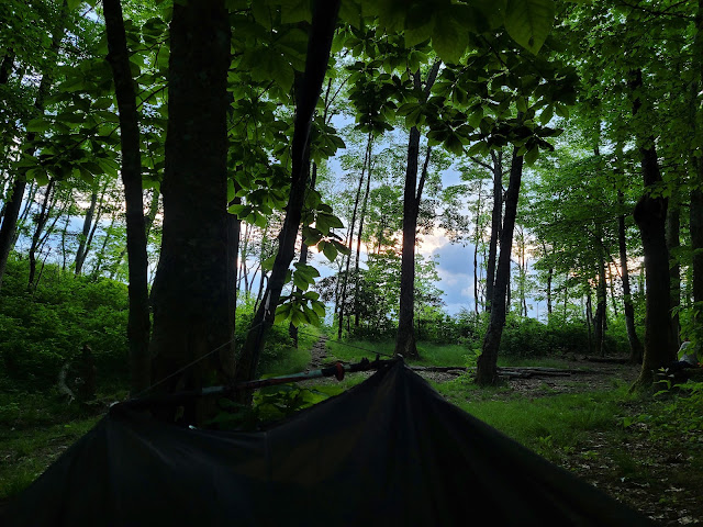
The view from my hammock

Wesser Bald Shelter, Appalachian Trail
Sunrise from Wesser Bald Shelter


Wesser Bald Shelter, Appalachian Trail
Wesser Bald Shelter

Wesser Bald Shelter, Appalachian Trail
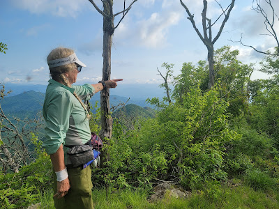
The view north to the Smokies


Wesser Bald Shelter, Appalachian Trail
Mountain Laurel in Bloom

The clouds are much thicker than yesterday, and shafts of light peeks through edges of the clouds over the ridge. I watched the sunset to the west of the ridge last night, and hoped to get a beautiful sunrise this morning. I must have missed it... I am packing up when I realize I didn't miss sunrise at all.  We are high enough on the ridge that the sun illuminates the sky for an hour before making an official appearance!  

The ill-prepared couple weathered the night well in the shelter. Just Gordon and Karma talk to them before we leave, admonishing them to return to their car and give up this foolish attempt. Continuing on the trail without a map or water filtration, let alone a modicum of experience, would be folly in this heat. So many people think the AT is just a walk in the woods. This trail breaks a lot of people who are unskilled in the ways of the wild.


Nantahala Outdoor Center, Appalachian Trail
Clingman's Dome is right here!


Nantahala Outdoor Center, Appalachian Trail
Down, Down, Down


Nantahala Outdoor Center, Appalachian Trail
The View North


Nantahala Outdoor Center, Appalachian Trail

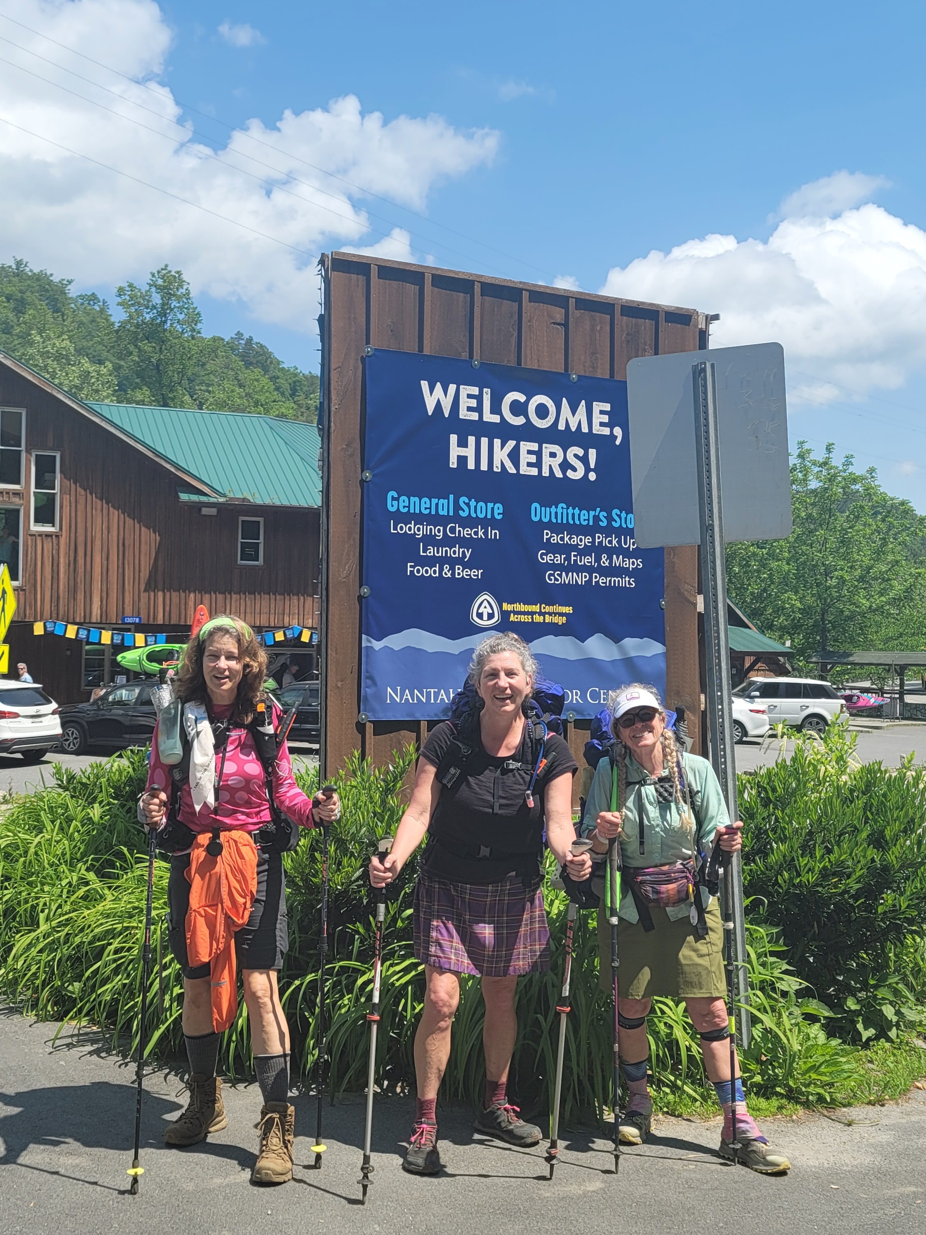
We are eager to get to the Nantahala Outdoor Center (NOC), a destination resort for outdoor activities like whitewater rafting and hiking, and a popular tourist trap for day trippers. NOC is only 6 miles away, but we have a 3,000' descent.  Prophylactic ibuprofen to the rescue! My knees will thank me later :-)


Nantahala Outdoor Center, Appalachian Trail


Nantahala Outdoor Center, Appalachian Trail
Orange Azaleas

Should one elect to tour by car between Springer Mountain, Georgia and the northern terminus of Mt. Katahdin in Maine, the trip would cross 1400 or so miles. Hiking the backbone of the Appalachian Mountains increases the mileage by another 700 miles. The AT runs generally from north to south. Currently we hike due north, although sometimes the trail makes an abrupt jaunt to the south, then east, then northwest before resuming it's progress. 
Once we cross into Smoky Mountain National Park the trail meanders northeast for 75 miles before abruptly turning north again.  Almost the entire descent into NOC we behold the profile of the Smoky Mountains, still 35 miles away but the most prominent ridge on the horizon in any direction.  My heart skips a beat when I imagine the physical suffering after we cross Fontana Dam. Thankfully this prospect is several days in the future and our bodies will be more prepared for the elevation. Or they may be more broken!  

Right now we have burgers and beer on the brain! We stop occasionally for pictures but plan to eat on the fly so we can get down.  The first half of the hike is a very steep decline and rocky, hard on the knees.  The last 2 miles or so is less difficult. The rumble of motorcycles from the approaching road causes us to speed up.  

Nantahala Outdoor Center, Appalachian Trail

The NOC is an amazing waypoint in this section!  Today is a Saturday and very sunny. There are tons of cars, motorcycles, and general milling about. They smell and look clean. We check into our bunk cabin, which is a room half the size of my bathroom with 4 bunks. But hey! There's air conditioning, so it's perfect!  We walk down the very large hill to the general store for laundry.  A salad, beer, and wrap sets me back almost $40.  A train from Bryson City rolls in with many more visitors. We sit on the promenade next to the river. I could stay here for a while, but probably would go broke in the process. We shop, do more laundry, shower, eat some more food, drink some more beer, and drop another 50 bucks.  Next thing you know it's 10 pm and we gotta get hiking tomorrow morning...

Nantahala Outdoor Center, Appalachian Trail


Nantahala Outdoor Center, Appalachian Trail


Nantahala Outdoor Center, Appalachian Trail


Nantahala Outdoor Center, Appalachian Trail

Todays stats: 6 miles,  350' elevation gain (not a typo!)

Section stats: 65 miles, 14k' elevation gain

AT total: 136 miles, 30k feet elevation gain


Appalachian Trail Day 13 - Wayah Shelter to Wesser Bald Shelter - Bear in Camp! (Mile 120.4 to mile 131)

Last night was a rough one.  Around 2 am, in a half-dreaming state, I roll over to go back to sleep, thinking for a second I should get up and water the leaves while I am slightly awake...  I drift off, dreaming of fireflies around a campfire, then bolt awake. These aren't fireflies drifting outside my tarp! There are lights shining INTO my tarp.  I can't hear anything, then realize my earplugs are muffling the sound of people talking rapidly and pointedly in my direction.  Laying in my hammock I pull up the side of my tarp. 

"What's going on?" I shout up the hill to the shelter. I can see several people walking back and forth with bright headlamps shining about.

"There's a bear!" replied one of the men on the hill reply.

"Where?" I ask.

"Behind your hammock."

Appalachian Trail Day 12 - Franklin, NC to Wayah Shelter - Views for Days!! (Mile 109.4 to mile120.4)

We are rested, refreshed, and clean! At least for an hour or two. Karma and I warm up for our hike by walking a mile to a Dollar Store for Gatorade sticks and McDonalds for breakfast while GG is packing!


The bus picks us up at the hotel, and we are returned to Winding Stair Gap around 10:30 am.  The sun is shining and the temp is heading for 90*  as we head up. The one thing about being in a gap means that you are standing in a low point between 2 peaks. Town days mean a big hike down, then a bigger hike up to get out of town and back on the trail.  A waterfall winds down the mountain, welcoming us back to the trail!

Appalachian Trail Winding Stair Gap


We are rejuvenated, but also weighed down by another 4 days of food. Each day's food is 1.5 to 2 pounds, more if we pack wine or whiskey for the evenings. Water is getting a little more sketchy as well, so when we fill up with a couple of liters, in addition to the food, we may carry an extra 10-15 pounds.  

Today our first big hike is to Siler Bald. This is a very popular local day-hiking destination, and many hikers with day packs are passing us on the trail. We meet a group of 6 women enjoying a nature hike. We talk about plants and life on the trail.  

Siler Bald Appalachian Trail
GG is under that pack somewhere!

A bald is a mountain summit covered by dense native grasses and low shrubs instead of woodlands. The views are often stunning, and Siler Bald did not disappoint! We are amazed by the view of Franklin and the the distant edge of the Smoky Mountains.  We have hiked so far, and yet still need to go 50 miles until the southern Smokies.  Karma and GG head to the top of Siler, but I want to take some time to journal and enjoy the scenery from a lower vantage. I pull out GG's chrome dome umbrella to escape the intense sunshine. 

Siler Bald Appalachian Trail


Shortly after leaving Siler Bald, we spy a downed tree covered in Chicken of the Woods mushrooms. Ugh!  I would love some but we have so far to hike today!  My pack is so full there is no room for them, anyway!

Chicken of the Woods mushrooms

Some really awesome women gave us some trail magic of Pringles, Slim Jims, and Snicker's Bars!!  This day keeps getting better and better!  Our next stop is Wayah Bald, a highlight of this area with an old stone fire tower. The temperature is stiflingly hot.  The hill won't stop, and the black flies are awful! I stop behind every large tree that provides a respite from the sun.  Finally we crest the rise of the mountain. I collapse in relief! But only for a second, until the black flies start biting again.


Wayah Fire Tower was built in 1937 by the Civilian Conservation Corps (CCC) on the highest point in the area as look-out for forest fires. According to Wikipedia, "Wayah Bald received its name from the Cherokee natives. It was named "Waya", the Cherokee word for wolf, after the red wolves that once inhabited the area. Spear points found on the bald indicate that indigenous people used the area as hunting grounds more than eleven thousand years ago."  Signs at the top show the locations of the area's peaks. Karma is pointing to Siler Bald. It looks so far away - hard to believe we were just there a few hours ago!!


We linger at the shelter for a while. The cell service is great so we call home and talk to our spouses and family.  The next shelter is a mile down the mountain. We need to head out so we can set up and eat before dinner!  GG sets up her tent down the hill, and I am on the fringe of the camping area in my hammock. We want to camp out as much as we can before the Smokies, where we are required to stay in a shelter if there is space. 

Joanie Cash came in at dusk and set up on the other side of Penny's tent.  She attempted to camp on top of Siler Bald last night.  She woke at 2 in the morning with lightening so frightful she packed up and hiked for several miles before she set up camp.  We passed by her this afternoon while she was sleeping. 

We are tired but the cool breezes will make for good sleeping on the mountain. The bears are concerning, but other than casual sightings, no trouble has been reported by other campers.  We have power in numbers, and there are about 15 people in and around the shelter.


Todays stats:  10.5 miles, 3000' elevation gain
Section stats:  50 miles, 11,000' elevation gain
AT total:  120 miles, 28,000' elevation gain
11,600