We are rested, refreshed, and clean! At least for an hour or two. Karma and I warm up for our hike by walking a mile to a Dollar Store for Gatorade sticks and McDonalds for breakfast while GG is packing!
The bus picks us up at the hotel, and we are returned to Winding Stair Gap around 10:30 am. The sun is shining and the temp is heading for 90* as we head up. The one thing about being in a gap means that you are standing in a low point between 2 peaks. Town days mean a big hike down, then a bigger hike up to get out of town and back on the trail. A waterfall winds down the mountain, welcoming us back to the trail!
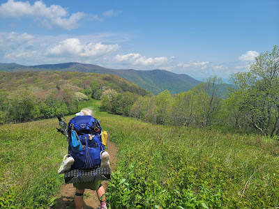
We are rejuvenated, but also weighed down by another 4 days of food. Each day's food is 1.5 to 2 pounds, more if we pack wine or whiskey for the evenings. Water is getting a little more sketchy as well, so when we fill up with a couple of liters, in addition to the food, we may carry an extra 10-15 pounds.
 |
| GG is under that pack somewhere! |
A bald is a mountain summit covered by dense native grasses and low shrubs instead of woodlands. The views are often stunning, and Siler Bald did not disappoint! We are amazed by the view of Franklin and the the distant edge of the Smoky Mountains. We have hiked so far, and yet still need to go 50 miles until the southern Smokies. Karma and GG head to the top of Siler, but I want to take some time to journal and enjoy the scenery from a lower vantage. I pull out GG's chrome dome umbrella to escape the intense sunshine.
Shortly after leaving Siler Bald, we spy a downed tree covered in Chicken of the Woods mushrooms. Ugh! I would love some but we have so far to hike today! My pack is so full there is no room for them, anyway!
Wayah Fire Tower was built in 1937 by the Civilian Conservation Corps (CCC) on the highest point in the area as look-out for forest fires. According to Wikipedia, "Wayah Bald received its name from the Cherokee natives. It was named "Waya", the Cherokee word for wolf, after the red wolves that once inhabited the area. Spear points found on the bald indicate that indigenous people used the area as hunting grounds more than eleven thousand years ago." Signs at the top show the locations of the area's peaks. Karma is pointing to Siler Bald. It looks so far away - hard to believe we were just there a few hours ago!!
We linger at the shelter for a while. The cell service is great so we call home and talk to our spouses and family. The next shelter is a mile down the mountain. We need to head out so we can set up and eat before dinner! GG sets up her tent down the hill, and I am on the fringe of the camping area in my hammock. We want to camp out as much as we can before the Smokies, where we are required to stay in a shelter if there is space.
Joanie Cash came in at dusk and set up on the other side of Penny's tent. She attempted to camp on top of Siler Bald last night. She woke at 2 in the morning with lightening so frightful she packed up and hiked for several miles before she set up camp. We passed by her this afternoon while she was sleeping.
We are tired but the cool breezes will make for good sleeping on the mountain. The bears are concerning, but other than casual sightings, no trouble has been reported by other campers. We have power in numbers, and there are about 15 people in and around the shelter.
Todays stats: 10.5 miles, 3000' elevation gain
Section stats: 50 miles, 11,000' elevation gain
AT total: 120 miles, 28,000' elevation gain
11,600


.jpg)


No comments :
Post a Comment