Nav Bar

About     ♦   Foraging     ♦   Backpacking     ♦   Trail Food    ♦   Wild@Home    ♦    Links    ♦   Demeter's Wild @ Home Store

Emergency Essentials/BePrepared

Appalachian Trail Day 13 - Wayah Shelter to Wesser Bald Shelter - Bear in Camp! (Mile 120.4 to mile 131)

Last night was a rough one.  Around 2 am, in a half-dreaming state, I roll over to go back to sleep, thinking for a second I should get up and water the leaves while I am slightly awake...  I drift off, dreaming of fireflies around a campfire, then bolt awake. These aren't fireflies drifting outside my tarp! There are lights shining INTO my tarp.  I can't hear anything, then realize my earplugs are muffling the sound of people talking rapidly and pointedly in my direction.  Laying in my hammock I pull up the side of my tarp. 

"What's going on?" I shout up the hill to the shelter. I can see several people walking back and forth with bright headlamps shining about.

"There's a bear!" replied one of the men on the hill reply.

"Where?" I ask.

"Behind your hammock."

I about fall out onto the ground. Penny emerges from her tent, looking a little dazed and confused.  We walk to the shelter. The 3 men staying in the shelter are outside with Karma. They said Joanie Cash woke them up reporting a bear was in the camp and ate "the food bags of the 2 women with the hammock." We check our food bags and they are tied where we left them and fully intact. 

"Did you guys see a bear?" I ask.  They unanimously did not, but Penny and I don't want to take a chance. We grab our sleeping pads and quilts and head for the shelter. Up until now I have avoided shelters like the plague. They are known for very active mice that reportedly crawl on your face and defecate on your clothes.  Mice are gross, but being eaten by a bear would really stink... 

Daybreak is beautiful, but everyone is tired, and the events of four hours ago seem to have occurred last month.   Bears are large and lumbering on first appraisal, but surprisingly agile and devastating when they find camps and food.  Would a bear be in our camp, we would see some evidence.  After a lot of discussion, we think that maybe Joanie had a dream in her exhausted state precipitated by the stress from the lightening storm the night prior.

After leaving camp, we see lots of trees gouged by bears...


Karma and I hike up to Wesser Bald Fire Tower. We are on top of a rickety wood structure waiting for Penny. She doesn't show up. We wait 30 minutes when I try calling her. 

"Hello?" the call drops.

"Hello?" the call drops.

We do this for 15 minutes when we get a text that she is almost at the shelter! She passed the fire tower without seeing the side trail. We head down the hill to a beautiful shelter area just past a gorgeous piped spring near the top of the ridge where we filtered enough water for dinner and tomorrows hike into NOC. 

We set up and sit in the shelter for dinner when a couple comes in. They are obviously exhausted. They are out of water, have no map, and have never backpacked before.  They are totally out of there element.  Just because you saw "A Walk in the Woods" (about an ontogenarian Robert Redford who made it 6 weeks with lots of yellow-blazing), doesn't mean YOU should walk in the woods without preparation!!  I offer them water from my bag, but Karma goes way further by walking back up the ridge to get them water. She filters it for them. Later, they walk up to the water and we are pretty sure they drank it unfiltered. They will probably not get giardiasis up this high, but it's a roll of the dice... 


Hammock Wesser Bald Appalachian Trail

Todays stats: 11 miles, 2200' elevation gain
Trip stats: 61 miles, 14K feet elevation gain
AT total: 131 miles, 30K feet elevation gain

Appalachian Trail Day 12 - Franklin, NC to Wayah Shelter - Views for Days!! (Mile 109.4 to mile120.4)

We are rested, refreshed, and clean! At least for an hour or two. Karma and I warm up for our hike by walking a mile to a Dollar Store for Gatorade sticks and McDonalds for breakfast while GG is packing!


The bus picks us up at the hotel, and we are returned to Winding Stair Gap around 10:30 am.  The sun is shining and the temp is heading for 90*  as we head up. The one thing about being in a gap means that you are standing in a low point between 2 peaks. Town days mean a big hike down, then a bigger hike up to get out of town and back on the trail.  A waterfall winds down the mountain, welcoming us back to the trail!

Appalachian Trail Winding Stair Gap


We are rejuvenated, but also weighed down by another 4 days of food. Each day's food is 1.5 to 2 pounds, more if we pack wine or whiskey for the evenings. Water is getting a little more sketchy as well, so when we fill up with a couple of liters, in addition to the food, we may carry an extra 10-15 pounds.  

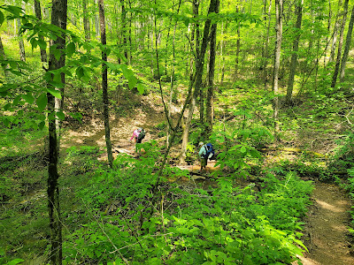
Today our first big hike is to Siler Bald. This is a very popular local day-hiking destination, and many hikers with day packs are passing us on the trail. We meet a group of 6 women enjoying a nature hike. We talk about plants and life on the trail.  

Siler Bald Appalachian Trail
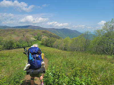
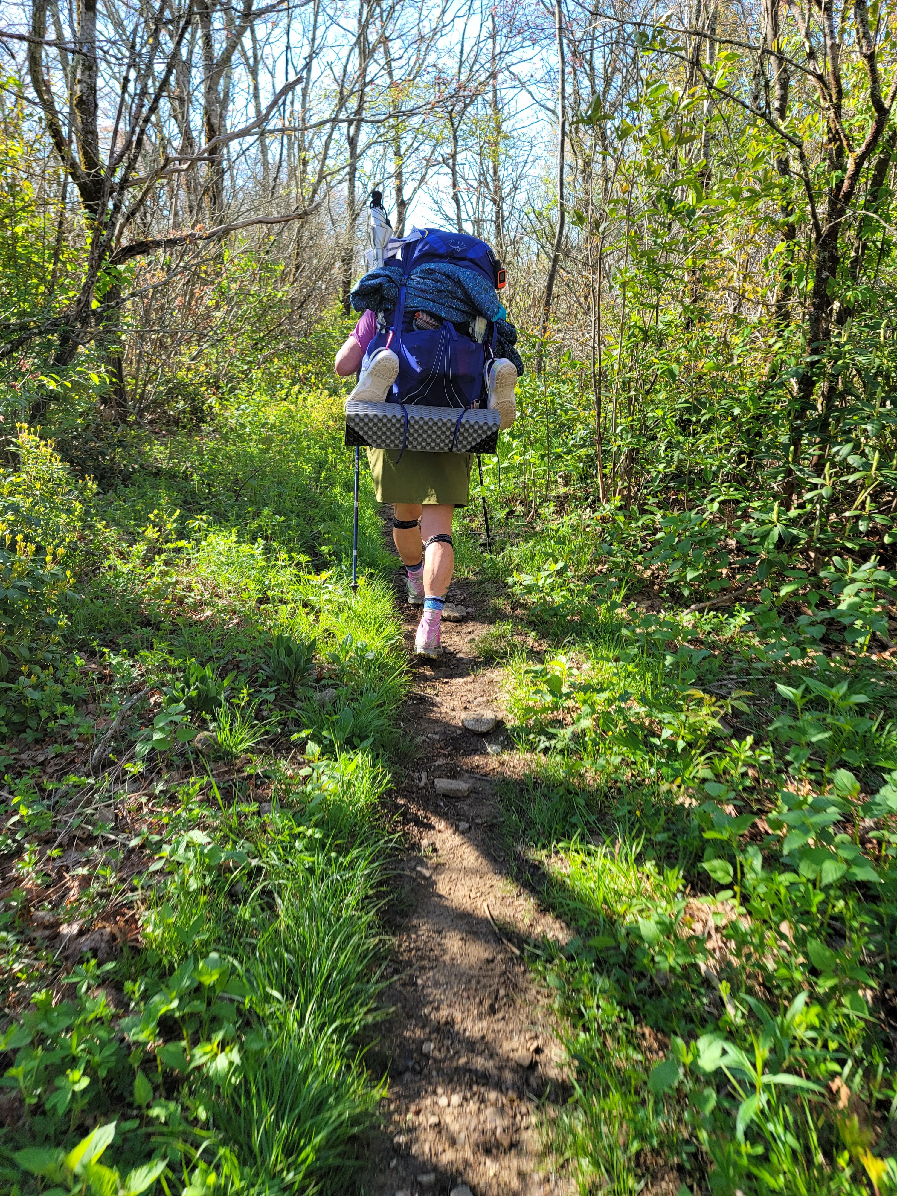
GG is under that pack somewhere!

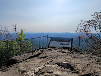
A bald is a mountain summit covered by dense native grasses and low shrubs instead of woodlands. The views are often stunning, and Siler Bald did not disappoint! We are amazed by the view of Franklin and the the distant edge of the Smoky Mountains.  We have hiked so far, and yet still need to go 50 miles until the southern Smokies.  Karma and GG head to the top of Siler, but I want to take some time to journal and enjoy the scenery from a lower vantage. I pull out GG's chrome dome umbrella to escape the intense sunshine. 

Siler Bald Appalachian Trail


Shortly after leaving Siler Bald, we spy a downed tree covered in Chicken of the Woods mushrooms. Ugh!  I would love some but we have so far to hike today!  My pack is so full there is no room for them, anyway!

Chicken of the Woods mushrooms

Some really awesome women gave us some trail magic of Pringles, Slim Jims, and Snicker's Bars!!  This day keeps getting better and better!  Our next stop is Wayah Bald, a highlight of this area with an old stone fire tower. The temperature is stiflingly hot.  The hill won't stop, and the black flies are awful! I stop behind every large tree that provides a respite from the sun.  Finally we crest the rise of the mountain. I collapse in relief! But only for a second, until the black flies start biting again.


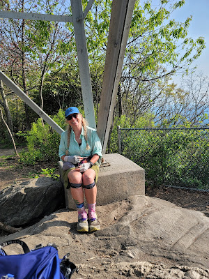
Wayah Fire Tower was built in 1937 by the Civilian Conservation Corps (CCC) on the highest point in the area as look-out for forest fires. According to Wikipedia, "Wayah Bald received its name from the Cherokee natives. It was named "Waya", the Cherokee word for wolf, after the red wolves that once inhabited the area. Spear points found on the bald indicate that indigenous people used the area as hunting grounds more than eleven thousand years ago."  Signs at the top show the locations of the area's peaks. Karma is pointing to Siler Bald. It looks so far away - hard to believe we were just there a few hours ago!!


We linger at the shelter for a while. The cell service is great so we call home and talk to our spouses and family.  The next shelter is a mile down the mountain. We need to head out so we can set up and eat before dinner!  GG sets up her tent down the hill, and I am on the fringe of the camping area in my hammock. We want to camp out as much as we can before the Smokies, where we are required to stay in a shelter if there is space. 

Joanie Cash came in at dusk and set up on the other side of Penny's tent.  She attempted to camp on top of Siler Bald last night.  She woke at 2 in the morning with lightening so frightful she packed up and hiked for several miles before she set up camp.  We passed by her this afternoon while she was sleeping. 

We are tired but the cool breezes will make for good sleeping on the mountain. The bears are concerning, but other than casual sightings, no trouble has been reported by other campers.  We have power in numbers, and there are about 15 people in and around the shelter.


Todays stats:  10.5 miles, 3000' elevation gain
Section stats:  50 miles, 11,000' elevation gain
AT total:  120 miles, 28,000' elevation gain
11,600

Appalachian Trail Day 11 - Culvert campsite to Franklin, NC - TOWN DAY! (mile 98.2 to mile 109.4)

We had a restful and uneventful night at the culvert camp. We head out early knowing tonight's destination is Franklin, NC; a trail town where we will resupply, get a hotel room with shower and do laundry!! And real food and a craft beer!!  A Town Day puts a bounce in our steps. We have no idea how we will get into town from the trail, but hitchhiking is always a possibility! But first, we have 11.1 miles and some hills to go...

Appalachian Trail Section Hike
GG and Karma Trekker down the hill

Today is a milestone on the trail. Literally. The 100 mile mark is less than 2 miles up Albert Mountain. The climb is straight up carved stone steps for 700 feet. A fire tower located in a clearing on the top of the mountain offers spectacular views; some of the best we have seen so far, and a promise of what the trail will increasingly offer in the Smokies. 


Albert Mountain Appalachian Trail
Albert Mountain Fire Lookout Tower


Appalachian Trail
Mile 100


The day is beautiful. We have been blessed with lots of sunshine and mid-70's so far, which is a blessing. However the pests are ferocious!  Black flies are biting me in a crazed, swarm like way every time I stop to soak up some sunlight. The little beasts prefer the slashes of light streaming between the trees over shade, so I learn to rest only in the shade of the large tulip poplars and sycamores. 

Around noon we descend into Rock Gap. A small parking area and a trash can looks like a great snack stop. We have loads of trash we carried for days.  A small bus pulls up and lo and behold a whole bunch of backpackers disembark. They are clean and look so fresh! A sign in the window advertises shuttles to and from Franklin for 5 dollars!  The driver informs us that the last shuttle from Winding Stair Gap is around 3 pm. If we hurry we can meet the shuttle and won't have to hitchhike. 

We see Smiles!! I thought for sure he would be way ahead of us, but he enjoyed a town day with the other hikers. We meet Broadway, Kabu, and lots of other hikers who tell us about the great food they had in town. The excitement is short-lived as we immediately have a 700' gain with full bellies in the increasingly hot weather. We pass a southbound slack-packer whose name is Just Gordon. Slack-packing means you day hike with a lightweight pack, and shuttle between spots. A lot of people will slack in and out of trail towns and stay in town 2 or 3 nights at a time. 

The shuttle picks us up at 3:30. On the bus, heading from town to Rock Gap, is a lone female backpacker named Joanie Cash. She tells us about the brewery and food trucks. We are salivating!!

We arrive in Franklin around 4 pm. By the time we check into Hilltop Inn (the former Ron Brown's Haven), shower, start laundry, pick up the boxes of food and supplies we mailed ahead 2 weeks ago, and eat dinner. By the time we start to repack it's 10 pm and tomorrow's first shuttle is around 9 am. The weather is too nice to zero here, and we still have 160 miles to go, so a quick turn-around.  We have one king bed, and Kelly decides to sleep on the floor.  We have our Tramily! 


Appalachian Trail
Franklin, NC


Todays stats: 11.1 miles, 1700' elevation gain
Section total: 40 miles, 8000' elevation gain
AT total:  111 miles, 25,700' elevation gain

Appalachian Trail Day 10 - Standing Indian Shelter to campsite above the Culvert - Our new Tramily!! (Mile 85.9 to mile 98.2)


Last night the wind was wild, but fortunately the only wild encounter. Our food bags are intact. The weather is clear and crisp. We start each day with a general idea of where we want to finish, as Shelters are located approximately every 8 miles. The next shelter is Carter's Gap,  which is reputable for a big bear problem.

Appalachian Trail North Carolina

The AT in is section is almost like a path, but then the rocks start pushing up into the trail, challenging us to be more alert to hazards, reminding us to keep our eyes on the ground. 

 Rhododendron in bud, but no blossoms yet.  The Azaleas are a brilliant orange color. The mountain laurel are showing promise of flowering in the weeks to come. 

Appalachian Trail North Carolina


Appalachian Trail North Carolina


We filter water at Carter's Gap. This shelter is notorious for bears that have been bluff charging hikers to steal their food, and also figured out how to cut through bear bag lines, as well as climb out on limbs to break the branches and then attack the food once the bags are on the ground.  Even bear canisters are not immune to breaches, as the bears roll them down the side of the mountain!  Someone has carved a warning to other hikers in the shelter.

Appalachian Trail North Carolina

We meet Buddy,  and ATC (Appalachian Trail Conference) volunteer. He informs us this area was once a bear refuge, but now there is a discussion of hunting the bears to control the problem.  We ask why there are no bear proof food boxes or cables, which are present at many other shelters. Hikers love bear proof hangs, and use them when available. He says the head honcho is worried people would use them as trash receptacles. We wholeheartedly disagree!
Appalachian Trail North Carolina

We continue to Betty Creek Gap - a camping area Buddy said is safer from bears - but the Far Out app we use has comments to the opposite. There is a food bag with ripped open packages of nut butter, tuna fish, and bars. We are tired and hot, but decide to continue up the trail, deeper in the National Forest, where bears are more likely to be hunted, making them more wary of people.

As I cross Mooney Gap, a man in a truck passes slowly, then turns around to pass back by. I am on the side of the road waiting for Penny. The vast majority of our encounters are pleasant and not threatening. People just want to talk with hikers!  The man asks where a trail is, but I am unfamiliar with the area. I position myself on the edge of the trail, ready to take off if I feel any weird vibes.  He asks about bear encounters, and if I have a gun. This is a question we get all the time. Frankly, I don't feel threatened in the slightest about needing one here. Grizzly country is another matter!  He shows me his sidearm.  I get a little prickly when a stranger shows me a weapon. It's one thing to talk about having one, another to pull it out.  I deduce he is harmless and making small talk, but I knew it would frighten Penny so I wait for her to breach the hill and I quickly say "good talking to you, but we gotta keep going!"

Just up the hill is a culvert pouring out beautifully clean water. A couple who is hiking through informs us of a campsite just above the water. We are so thankful to be able to stop for the night. Shortly after we start setting up camp, a tall woman arrives with a big smile, clean clothes, and a pack stuffed with all kinds of cool things. She is Karma Trekker and has just hiked 17 miles to make it through the bear situation. She is tired and asks to camp with us. We are thrilled to have another woman in camp. The women have really outnumbered the men on this section. We eat with Kelly, and she regales us with tales of her section hike. She has been away from home almost a month, hiking sections of the AT and camping in her car tent. She shows me awesome flower and snail pics taken with her phone. She uses a macro lens and the results are amazing! 

Just before dark (and hiker midnight) a man named Mike enters camp. We assure him we have plenty of room.  Mike is a rep for Gossamer Gear and has an awesome tarp set up. He has hiked the Continental Divide Trail (CDT) and the Pacific Crest Trail (PCT).   He says the Appalachian Trail looks like it will be harder. The other trails are higher peaks, but the AT has more overall elevation gain and loss. 

Todays stats: 12.7 miles, 2300' elevation gain
Section total: 29 miles, 7300' elevation gain
AT Total: 98 miles, 23,000' elevation gain

Appalachian Trail Day 9 - Plum orchard Shelter to Standing Indian Shelter

The entire camp is up at 6:30. A quick breakfast and on the trail by 7 Am. NC/GA state line at 9:30. We gained 1200 feet over the last 4 miles. The group we camped with last night is fleeter of foot  (and much younger) and continues up the trail. They are planning on 20 miles to get to Franklin to resupply.

A huge milestone today! We crossed into North Carolina!! The trail crosses through 14 states from Georgia to Maine. One state down, 13 more to go. 
appalachian trail
One state down, 13 more to go!

Shortly after crossing into NC, hikers encounter "the tree," a sprawling old beauty right in the middle of the trail. She appears mystical in the morning haze. Is she welcoming or warning approaching hikers? 

 Steve, a weekend hiker we meet at Muskrat Creek Shelter, saves the day when Penny accidentally drains her dirty water straight into her clean water bags without the filter. 


Muskrat Creek Shelter

Our hike finishes with a never-ending hike down and up to Standing Indian Shelter. I am bonking in a big way. The weather is hot, and we are sweating copiously. I need more salt and sugar in my diet!

Reports of bear activity are the talk of the trail, with increasingly aggressive bear encounters worrying the backpackers. We see no bears, but lots of scat.

Penny and I have Ursacks -  a Kevlar bag, when tied appropriately to a tree is supposed to keep your food safe - although there are reports of these being taken.  

We are surprised to see the group of 5 from this morning.  They decided to stop here because the bears are worse in the next section.  Stretch helps me tie my Ursack. 


A fire and off to bed!

Today's hike:  3300' elevation gain, 12.1 miles
Total hike: 4321'  gain, 13.6 miles

Appalachian Trail Day 8 - Dick's Creek Gap to PIum Orchard Shelter ( miles 69 to 73.7 )

We Stayed in a hotel in Asheville, NC last night. 6:30 am we are off to the races. We Packed last night In preparation of an early start this morning. The hotel is 45 minutes from Hot Springs, where Kate is meeting us at 9. 

We park behind Laughing Heart Lodge. The proprietor, Gabe, is in the kitchen finishing breakfast service. He keeps an eye on the hiker's cars, and we donate the remainder of our fresh fruit and veggies to the hostel kitchen. 

An antique forest green Jeep Wrangler pulls up in a small cloud of dust.  A kind and handsome woman emerged with a black dog.  Kate and the pup named Hiker drive us on backroads of NC. Kate is fun and talkative, and the 2.5 hour ride passes quickly.


Back on the trail! 80°F and sunny.  The hike out of the Gap (a southern term for the passage between mountains) is a moderate uphill.  We meet Smiles, who is a delightful teenager with an infectious smile.  He is through- hiking alone.  

We reach Plum Orchard Shelter for a snack. Penny wants to stay here.  We meet a group of 2 men and 3 women who met on the trail and are now a " Tramily," or Trail Family. 

We enjoy light banter over a dinner of freeze dried meals rehydrated with water filtered from the nearby spring, then boiled on our camp stoves. The 3 young women are recent Masters Grads who decided to pursue the Trail instead of jobs. They are so cute!


Today: Elevation - 1500' , miles - 4.6

The sun sets, and Hiker Midnight is upon us.  With no TV, artificial light, or cell phone reception, the hiker's tuck into their respective tents and hammocks to read. Sleep is not far beyond...


Appalachian Trail Day 7 - Unicoi Gap to Dick's Creek Gap and Hostel Around the Bend (mile 52.5 to mile 69)

Day#7 10/27/21 Last day of this journey, had to cut it shorter than our plan but will pick up where we left in the Spring.  Amy is already planning our trip for our Appalachian Trail continuation. This hike was our longest so far total mileage 18.9 / 11hrs 21 min. We had to finish in the dark the last 2 Miles. We started at Unicoi gap after a shuttle from Lisa, we slacked packed, which is taking out everything except snacks, water, water filters, extra clothes for cooler temps, head lamps. The hike started out climbing Rocky Mtn, we stopped at a cool site “Cheese factory Site" for lunch, meet a solo female hiker Lisa Webster Mathews and her dog Regina.  They were section hiking she was on her way to Unicoi Gap. Discovered she is also a trail runner and TJM nation and has run Badger Trail race in WI same one I want to run next August 2022. Small world I have said many times! We then hiked to Tray Mtn with such beautiful views and the Foliage was spectacular.  Finally finished our hike for this trip. Both of us were tired but happy with our journey. Arrived back at the Hostel with a group of friends that we discovered all nurses having a getaway. Very lively group, they departed after their partying to their cabins. Silence is golden when tired! Washed clothes, well deserved shower and packed up for tomorrow trip home. Sorry we had to cut it short but glad we didn’t have to deal with a multi-day storm. 


My favorite wool pants after a fall