Nav Bar

About     ♦   Foraging     ♦   Backpacking     ♦   Trail Food    ♦   Wild@Home    ♦    Links    ♦   Demeter's Wild @ Home Store

Emergency Essentials/BePrepared

Appalachian Trail Day 113 - Lehigh Gap to Wind Gap (Mile 1261 to Mile 1281)

I wake up at 5:00 am.  Kelly is laying across her bunk with her sleeping bag over her head and her feet hanging off the side.  I grin at the sight, but even more so when she sits up abruptly, hair askew and eyes half closed.  

Grit and Terminated are already awake. We are mostly packed so we just have to get everything out of our bunks without disturbing Ladybug who is the only one still sleeping.  Everyone who stayed here last night will be staying at Breezy Acres tonight, with the exception of the man from Quebec.  Kelly and I offered to slackpack everyone.  The gentlemen deferred, but Ladybug jumped at the chance.  I have a trash bag with her sleeping pad, sleeping bag, and everything else in her backpack that she won't need for the day, which will allow her to hike more easily today.

Kelly and I have a big day planned.  We are going to do our first 20 mile day, hiking from Lehigh Gap to Wind Gap. The hostel is 15 miles southwest of Lehigh Gap, so we are going to drive my truck to Wind Gap and drop it off, then drive back to Lehigh Gap to start our hike.


We get our vehicles repositioned and we are on the trail around 8 am. The trail starts out rocky and steep, but it is manageable for the first half-mile. We are only 30 minutes into our 10 hour hike when we come to our first roadblock. 

Appalachian Trail Day 112 - Lookout Hostel to Lehigh Gap (Mile 1247 to Mile 1261)

We were up early this morning and drove one of the cars to Lehigh Gap and then return to Lookout hostel where we start our journey around 8.  The fog is thick and the air is saturated with water from the all night soaker we had last night. 

We cross Route 309 in front of the Thunderhead Lodge to get back on the AT.  

The hike today is going to be relatively easy in terms of elevation gain. We have a little bit of climb from the road, but the trail starts off easily enough. The woods are really dark this morning and the trees are dripping so much water it feels like rain is falling down. 

Almost as soon as we start, we see a big cluster of tents to the left of the trail in a clearing. The campers inside must be soaked.

The trail is really nice for the first few miles or so except for a few very rocky but short sections. A few rock ledges are purported to have beautiful views, but there will be no views for us today, so we don't tarry.


About two and a half miles into the hike, the rocks become decidedly bigger and closer together. We encounter our first big rock scramble today called Knifes Edge. 

Knifes Edge is at the top of the ridge, featuring huge, exposed slanting rocks cleaved off in layers.  We need our hands to climb and crawl across the rocks, trying to keep three points of contact at all times.  The rocks are worn from years of untold people scrambling over them,  and the wet conditions serves to complicate our passage, but we scramble and slide and make it through unscathed. I think it's challenging but fun.


We hike downhill from Knifes Edge and cross a gravel road with a huge parking lot.  A sign states this the the "Bake Oven Knob Parking Area."  This must be a very popular hike, judging from the size of the parking lot. We follow the white blazes across the parking lot and start uphill again.  The rocks start up again and we are in Bake Oven Knob.  These rocks make Knifes Edge look easy.  We climb over and around huge boulders and by the time I  throw my poles down some big boulders,  I am as mad as a hornet that got splashed. 

I throw a temper tantrum of sorts and tell Kelly that im not doing any more of these ridiculous rock climbs again today in this rain.  It's just too dangerous and I want to live to hike another day.  Fortunately for me, we didn't encounter any more,  because there were no side trails to bypass these rock features anyway.  


We are making our way over some rocky spots when a young lady comes up from behind and asks if she can go around. She's moving fast and obviously a through hiker. We end up being able to keep up to her and we talk for the next couple of hours. She was one of the campers in the tents at the bottom of the hill this morning. Her name is Fizz and she is from Maine so she is working her way home. It's so nice to talk to young people out here, because they have no worries and their outlooks are always so cheery. They don't have the concerns or aches and pains of the rest of us older folks.

We passed under an open power line, and the trail becomes a rock garden. Literally a garden, because there is mulch spread in between the big rocks. It's obviously intentional, but I can't understand why anybody would want to go to the trouble of spreading mulch here. Kelly, Fizz, and I stand there and try to figure out why. Perhaps they had to remove trees and decided to chip them in place I wonder.


One of her tramily (trail family) catches up to us.  His name is Toad and he decides to wait at the Rock Garden for the rest of the family while Kelly is and myself continue forward. Fizz decides to keep hiking with us. A cooler full of fresh water and snacks is near a road crossing, courtesy of Breezy Acres Hostel. We find some blueberries that are actually ripe. Only a few, but we are excited at the prospect of fresh fruit on the trail in the coming weeks!

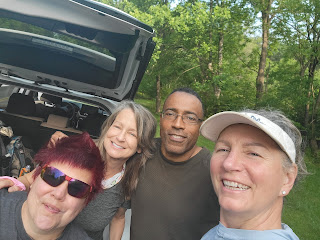
Now that we've had an extremely small snack, our stomachs are gurgling for food. We decide to look out for a nice campsite to stop for lunch. We find one a short time later; a spot under some eastern hemlock trees with really nice soft carpet of fresh pine sheds. We are enjoying our lunch when the two men from Warrior Expedition arrive. We chat while we are snacking on our lunch and we all take a picture together. They are probably going to be way ahead of us soon so I know we're not going to see them again.


The trail starts to slope downward and the trees become less dense as we start the long descent to Lehigh Gap.  For the next mile, the open landscape affords us sweeping views of the valley below, albeit shrouded in the  yellow haze of the wildfires.  

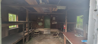
We are about halfway down the hill when the trail runs feet from the George W. Outerbridge Shelter. This is a really cool shelter. It looks super duper old, and the shelter looks like it was built from the raw materials of the woods around the shelter. 

Kelly, Fizz, and I continue down the trail, which descends rapidly down the remainder of the hill. Fizz stops to filter some water and Kelly and I emerge from the woods and onto a bridge that is under construction.  We dodge construction workers and equipment as we walk over the Lehigh River. 


George W. Outerbridge Shelter, circa 1967


The Lehigh River


We finish our hike and return to Lookout Hostel after a quick trip to Walmart to pick up some food to eat tonight.  We are pleasantly surprised to see Ladybug at the hostel, along with three other men.  They all stayed at the Eckville Shelter last night, and she is ready for a shower and clean clothes.  Kelly and I also want to shower, but we are cleaner than the four of them.  Plus, the guys really stink!  Ladybug lets one of the stinky men shower before her, and we get them to start their laundry right away to mitigate the stanch in the tight quarters of the bunk room. 

Later, we are lounging in the living area.  I am chatting with Terminated and Grit, and they are a lot of fun to talk to.  Another gentleman is from Quebec and we pass a few words in French.  I love the language but my vocabulary and pronunciation is horrific so I jump at the chance. 

Terminated picks up a guitar and starts strumming to our delight, but it's late so we don't spend much longer until we are ready for bed.  

Today's Stats: 14 miles, 1,375 feet gain, 2,267 feet loss
Trail Stats: 1,261 miles, 256K feet gain, 263K feet loss

Appalachian Trail Day 111- Eckville Shelter To Lookout Hostel (Mile 1235 to Mile 1247)

I wake up At 5:30 exactly. The bed was comfortable enough, and the room is very quiet, but I was burning up in the night because I was using my down top quilt as a blanket.  I think my metabolism is in hyperdrive with all this hiking and eating.

I chat with the other occupants of the hostel. Mountain Man joins us for coffee, in addition to a woman flip-flopper, a long section hiker with a gorgeous husky named Beau is here. Beau is very sweet and rubs against my legs like a cat.

A man named Memory Maker comes in.  He camped out last night.  He's local from Philly, and he just did a short section hike and has to go home today. He's getting shuttled to Port Clinton so we will ride together.

I make some coffee and pick apart the remnants of my rotisserie chicken. I rummage through the fridge and find some bacon and make chicken quesadilla for breakfast. It is massive and loaded with calories.  I am trying not to lose weight on my hike, because I don't want to lose muscle. I am striving for 3,500 calories per day minimum intake with 200 grams of protein and high quality food, and it's working.  I am maintaining my weight and pretty sure I am gaining muscle in my legs. But even with the calorie intake, I am still hungry all day long.  

with Zoom Zoom and Memory Maker


Zoom Zoom drives Kelly and I to Eckville Shelter and we goodbye to her and Memory Maker. Ww want to start from the shelter since it will be demolished in the next couple of years.  We go inside the shelter and take a couple of pictures. Looking around, I'm really glad that we didn't want to stay here. This place really does need to be torn down.  It smells awful and looks like it is mice infested.

The Eckville Shelter

We start up the trail and it is 1,100 feet straight up for the first mile and a half or so. We were warned that it's a pretty awful hike, but I don't think it's as bad as some of the others that we've done. The terrain is not terribly steep or rocky.  Maybe I am just getting in better shape!

On the way up the hill, a tiny baby bird plops down on the trail beside me, chirps at me for a moment, and then flies away a few feet into a nearby bush. 

As we reach the top of the ridge, the rocks start popping up again. We climb some large ones and arrive at a lookout, but the Canadian wildfire smoke is back, and the sky is super hazy. It's like a yellow fog blanketing the valley.

After the view, the trail becomes very rocky with large boulders, but today I don't dread it. I'm expecting the rocks now and today I think they are rather fun. We are hopping from rock to rock, looking for snakes and I feel like I'm a kid on a playground. We've already done almost four miles, and they were so easy I don't feel as if I barely worked at all.


The views are pretty but still hazy from the wildfire smoke. We stop at a beautifully maintained shelter for a lunch break and enjoy the lovely parklike setting.

We are back on the trail, which is really a forest road, for the remainder of our easy hike today. We enjoy being able to walk side by side while we hike, as opposed to walking single file, where it's hard to hear one another at times. 


Before we know it we are back at the hostel. Many of the hostels on the trail have murals painted by a trail artist. I think the mural at The Lookout perfectly captures the surrounding hills and sweeping views. 

There is a full house at the hostel tonight because of the forecast for heavy rain later.  Two of the gentlemen are with the Warrior Expedition, a non-profit which provides therapy for veterans.  They are very nice and ask me when I plan on summiting Katahdin.  I reply that I haven't given it any thought because I am not sure if I will make it before the mountain closes.  They say they are doing the same mileage, and they are planning on summiting the second week of August.  I do some calculations and realize that with 15 miles per day I would have 63 days of hiking left!! I realize that summiting and completing the trail is possible this summer.


The hostel is a hubbub of activity with all the people here, and there is a line of sorts for laundry and showers. Thankfully we arrived before everyone else, so we finished our "town chores" before the line became too long. The living area is crowded with people and gear, and I enjoy spending some time chatting with the other. 

There is a hiker here who is obviously trying to not spend any money.  I have some laughs when he goes through the hiker box at my suggestion, and pulls out a ton of food.  The hiker box is a place where people can donate unwanted items.  There is always some weird and random stuff in there, but there can also be some great gear.  Oftentimes, the best stuff is when someone gets a resupply box sent to them at the hostel.  I have scored some amazing meals and electrolytes from the hiker box.  Anyway, Zen produces a pile of macaroni and cheese along with other assorted foods. I call it a "hiker box buffet."

Tad and his daughters arrive.  The rain is really pouring now and they will have to camp out because the bunks are all taken.  Because they are paying to stay on the hostel property, they can hang out inside the hostel and out of the rain for as long as they like. One of his daughters is a vegetarian, and she is cooking up something fabulous for dinner. 

Several of us go to bed early and one of the Warrior hikers turns out the lights.  


Today's Stats: 12 miles, 1,742 feet gain, 1,053 feet loss
Trail Stats: 1,247 miles, 255K feet gain, 261K feet loss

Appalachian Trail Day 110 - Port Clinton, Pa To Eckville, PA (Mile 1220 to Mile 1235)

I slept very comfortably in my hammock, and it didn't even rain!  My only complaint is that I had my in my ear plugs and I still managed to be woken up frequently by the loud road noise. Cars were flying up and down this highway all night long. I wake up at 4:30 a.m. and decide to check the weather. I see there are some storms moving through, so I decide to get up and pack up my camp and stash everything in my vehicle so that if it does rain my stuff isn't soaking wet.

Everyone is still sleeping in the hostel, so I make some coffee and go out to my truck to organize my things. 

When Kelly wakes up, we talk about our options. We were planning on getting back on the trail with our packs. The weather report keeps changing by the minute, and now the forecast is for some thunderstorms this afternoon. We mull it over and we decide that if the stars align and we can get a bunk for the night here and we can arrange a shuttle from Eckville, we will slack pack today as well.

I send a text message to Zoom Zoom and see if she's available to pick us up this afternoon. YardSale, the hostel owner, comes in and we ask her if she has bunks for the night and she says they are available. 

At almost the same time, Zoom Zoom texts back and says she can pick us up. Our stars in alignment and we now know we can just slackpack today. We get our day packs organized, and we drive to Port Clinton, where we left off yesterday, and we are on the trail minutes later.

The trail follows the Schuylkill River before heading up under a bridge. We cross a road and a gentleman in a car says that his brother and his brother's two daughters are hiking the trail and he is going to hike in with some trail magic a little way up. We tell him we can't wait to see him down the trail and start climbing up our first big hill of the day.

I was told that the trail out of Port Clinton is really difficult, and it is steep with a lot of big rocks, but it's not too terrible.  We make good time to the first big ridge, and we are cruising at three miles per hour until some big boulders pop up.

Appalachian Trail Day 109 - Eagle's Nest Shelter to Port Clinton, PA (Mile 1211 to Mile 1220)

I was up around 5:00 a.m. this morning and no one else was stirring in the shelter or the surrounding campsites. I started taking down my camp, appreciating that I didn't have anyone really close to me so I could use my headlamp on blast and didn't have to worry about waking anyone up in the process.

A few minutes later I can see Kelly's headlamp on the other side of the shelter grounds.  By the time I am packed, Kelly is making her way to the picnic table. Daddy Long Legs is awake and packing as well. We hang out at the picnic table while Kelly makes some coffee and soon it is full of hikers. 

We say goodbye and hit the trail by 6:30 a.m. I grab a liter of water when we pass a spring on our return to the AT. Today is overcast but thankfully it is warm and I'm not wearing any extra layers. 


Our hike into town is going to be short and sweet. We go up one steep and rocky hill, but most of our trek is level or descending, so I barely break a sweat all morning. 

Appalachian Trail Day 108 - 501 Shelter to Eagle's Nest Shelter (Mile 1196 to Mile 1211)

I started waking up around 4:30, but didn't get out of bed until five o'clock. Even being this close to the road, the noise level was not remarkable, and I slept pretty well even though I had really weird and vivid dreams, and I was really warm and had to kick off my down comforter a lot in the middle of the night. I think I'm going to have to get rid of my midweight sleeping woolies in exchange for something lighter.


Appalachian Trail Day 107 - Rausch Creek campsite to 501 Shelter (Mile 1180 to Mile 1196)

I slept like a log last night. I did not hear a thing, and I swear I barely moved during the last 10 hours. 
We are both up and packing by 5:30, and about 6:20 we are on the trail. The temperature in this valley near the stream is really chilly this morning, so I leave camp with my puffy jacket on. 

We continue a short way downhill, where a young man passes us very quickly.  His name is Nomad, and he is thru hiking, which if he didn't tell us we could have guessed by how fast he is moving. 

About 20 minutes after leaving the campsite, we arrive at an opening in the woods. The ground is flooded and the landscape dotted with the skeletons of tall dead trees.  At first, I wonder what is going on here, but then realize we are at the beaver swamp. I hiked on a beaver dam once before at Dolly Sods, and I almost went head over teakettle when I put my hiking stick in the wrong spot and it sank quickly between the sticks of the beaver dam.