I tossed and turned last night, but still wake feeling refreshed. I start packing at 6:30 am, just when the sun is starting to rise. There is a blanket of fog over the ridge top and the sky is hazy. I'm probably not going to get an opportunity to dry out my wet stuff in sunshine today. The current temp is 57F, and I catch a stiff breeze when the trees thin out, but for the most part the trees line the trail.
I only have 12 miles to go to get to the James River Bridge and Glasgow. I need to decide what to do next. I would like to get a little farther north, but it's lonely out here! I'm starting to see more people, but still nothing compared to the back of the hiker bubble I am used to hiking in. Plus, when I do see people, they are usually on a mission to make miles and get into town.
I talked to my husband last night and told him I may bail at Glasgow. I know I need to get into town because I am running out of food and my battery pack is completely dead. I used the last bit of power to juice my phone to 80%. I don't care if my InReach goes dead, but I would be in trouble if I can't call the shuttle to pick me up when I get to the bridge.
I'm starting to see a lot of fresh bear scat on the trail. If I would shut my trap and stop audio journaling, or turn off my audiobooks, I would probably see a bear. I see a very large pile of fresh scat followed by two smaller piles. Definitely a mom with a cub or two. Maybe I will just keep making noise to keep them away!
 |
| Fresh Bear Scat on the Trail |
Speaking of audiobooks, I am always on the lookout for a series of long, world-building fiction. When someone suggests a favorite series or author, I add the books to my wish list on Audible. Recently, a friend at work recommended the Mayfair Witch books by Anne Rice. I read them when I was in college, about 30 years ago, but don't remember anything about them, so I purchased the first book for this trip. The book is crazy long, over 50 hours! Perfect for a long, multi-day hike. I finished the first two books earlier on this trip, so today I am starting the third of the series. I love how she weaves her stories, but she certainly has a pornographic side to her writing.
 |
| Helianthus tuberosus, or Sunchokes |
Today I have three hills to climb, but none of them very high. I also will descend a lot more than I will gain in elevation on this trip. The first hill is a breeze, with just a couple hundred feet of gain before I descend down to a forest road. I must be close to the Blue Ridge Parkway, because I can hear a lot of cars moving in both directions. When I look at the map, I see that I am within spitting distance of the road.
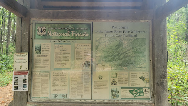
A sign welcomes me to the James River Face Wilderness at Petites Gap Trail. This is the first wilderness area established in the Virginia Commonwealth. The Appalachian Trail traverses the wilderness area for over nine miles, where I cross over the James River later today.
The weather is still overcast and foggy over the mountain ridges. I am a lot lower in elevation than I was the last couple of days, so I'm not affected by the haze.
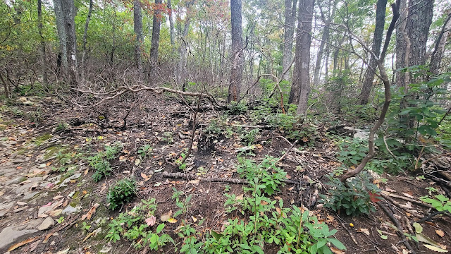
I walk through another huge burn area. This one looks to be a little older than the one I walked through yesterday; the underbrush is super thick, the tall and impenetrable bushes and small trees line the trail. Burned out trees lay in every direction, scattered like a scattering of pick-up sticks. Thank goodness I wasn't trying to find a place to camp here last night!
One tree is hanging in the air, suspended by another tree above, the burned out husk of the hanging tree doesn't even touch the forest floor!
I hike up and over Highcock knob, witnessing the aftermath of the fire for about an hour. One plant that is taking advantage of the fire is sassafras. The small trees are everywhere! As are black locusts and wood asters.
I reach a saddle in the woods where a sign announces a spring just down the hill. I take off my pack and filter a liter and enjoy all the plants in the clearing. Lots of Plantago major (plantain), goosefoot (Chenopodium album), and goldenrods dot the area. Even with the burned skeletons of the trees standing sentry over the clearing, the scene is quite pretty.
A lone woman hikes in, and we chat for a bit. We discuss how few women feel comfortable enough to hike alone in the wilderness and she tells me there is a man at Punchbowl Shelter who appears to be living there. He is nice enough, she says, but he tends to ask questions that she believes are a little personal for having just met someone on a trail, which comes across as creepy. Apparently, he is carrying a huge bible; a dead giveaway for someone who isn't out here to hike. Not that it's a bible, but rather that it's a large bible. No self-respecting backpacker would be caught dead with anything that isn't pocket sized!


At the Sulfer Springs Trail I meet a couple who have been thru-hiking since June 15, so almost two months. They inform me that they are in the front half of the Sobo bubble, which is appreciably smaller than the Nobo bubble. We chat about how different the Sobo experience is from the Nobo one. They tell me that they have had a little struggle to find space at hostels when visiting town and in shelters during bad weather. I think if I did this section a week or two later I would probably not have been quite so alone. Of course, they are all so fast that even if I hiked southbound, I would only see anyone once, because there is no way I would be able to put in the miles they are doing at this point in their hike.
Another mile I pass a young lady. She has her head down and her earbuds in, so I just say hello and keep walking. 10 minutes later I pass a gentleman, also heading southbound. This trail became busy all of a sudden! His trail name is Chopsticks and says he knows there are a lot of them on the trail. I mention that I know a Chopsticks who is hiking with No Rush, and they are in New England by now. He says he has seen their names in the trail registers. He flip-flopped and summited Katahdin last month. He just left Stanimal's hostel in Glasgow, as did the other hikers I recently passed. He says I should run into some more Sobo's over the next few days, but most of them are still in Shenandoah, another 80 miles up the trail.
I have to stop chit-chatting with everyone or I will never get to town!
The descent down from the ridge top to the James River Valley is treacherous. The fire burned off the top layer of vegetation, which fires do, making the soil susceptible to erosion during rain. The erosion created frequent washouts, and the trail is littered with pieces of flat and slipper shale. I have to pick my way gingerly across the ridge top and hike down, losing over 2,000 feet in three miles.
Views of the James River have been teasing me the entire way down as I follow a stream down the trail which looks like it could be a raging torrent in high water. I would love to take off my shoes and soak my feet, but it looks like I don't have any time to spare in meeting the shuttle driver.
I walk along the bank of the river for over a mile, catching sight of the footbridge which crosses the river. Signs warn against camping near the river and forbid jumping from the bridge, which is almost an AT tradition with the younger, more reckless crowd. I can't imagine jumping from this height into the muddy water below, but perhaps I would have done it in my younger years.
I am thinking of ending my section here. I'm just not feeling the scarcity of companionship on the trail. I can certainly tolerate it, and I love hiking by myself, but I miss having people at the shelters to talk to, and I find comfort in knowing that if I have an accident, someone will be along sooner rather than later. Not to mention, I get creeped out in shelters when no one else is around. I stealth camped every night, except for the night in BeeCh Hill.
Today's Stats: 12.6 miles, 1800 feet gain, 4500 feet descent
Trail Stats: 787 miles, 174 K elevation gain


No comments :
Post a Comment