

I am up at 5:30, but it's still dark. I pack up camp and go through my food bag to pull out my snacks. I make my breakfast; protein powder, chia and ground flax seeds, kencko fruit and vegetable powder, and instant coffee. Lots of protein and fibrous goodness to start my day! I sling my very heavy pack onto my back and get back on the trail as the sunlight just starts to illuminate the dark wood.
A short walk and I emerge onto the Blue Ridge Parkway and see a pull-off offering a view of the sunrise immediately in front of me! I take off my pack and plan on watching the sunrise, when I realize the sun is rising behind the trees to my left. So I heft my pack and head up the trail.


I continue on up the trail, enjoying the beautiful morning. The trail gains only 600 feet over the next 3 miles, which is about as flat as it can get out here. I meet a woman who is section hiking south from Waynesboro, at the southern entrance to Shenandoah. She tried through hiking last year, but was so dejected from the constant rain that she quit. She is from the desert and the rain is very foreign to her, so she decided she likes hiking in the dryer months. I totally get it. It sucks to carry so much water, but it's worse to hike through it day after day.
We also talk about how close the trail is to the road. It's nice for hitchhiking and getting rid of trash, but the road noise is constant. Nothing like the sound of a motorcycle gunned up a hill when you're enjoying nature! At least the noise is better during the week.


I stop at Bearwallow Gap, where a small stream runs next to the road crossing. This stream is so small that I can only scoop out about third-liter of water at a time, so this water stop will take me at least a half hour to filter an appreciable amount. The stream is only 6 inches wide in spots, but at least I can scoop out the sandy bottom so my filter bag can get a little deeper in the water. I grab handfuls of sand and small rocks and wait for the water to clear, looking at my map and munching on a snack.
The map notes that there is an inn called Peaks of Otter Lodge located near the gap, but it only operates a few months of the year, in the winter, so I can't cave to temptation and sleep in a real bed tonight. I have about a 1000 foot climb and about 7 miles before the gap where the campground is located. The problem is that the campground is 1.5 miles away from the trail. I could hitchhike, but I don't like to do it by myself. I can try to call the campground to see if they can pick me up, but cell service is so spotty that I have a suspicion I won't be able to get through.
I don't have to stop: I am carrying enough food to make it to Glasgow, only 30 miles up the trail. I should be able to get there in two more days of hiking. A shower, laundry, and electronic recharge would be nice, but I don't absolutely need it right now. I am definitely on the fence about stopping there for the night. I think if I feel really good when I arrive at the turnoff to the campground, I will keep hiking and make some extra miles. If I am on the struggle bus, I will get off trail for the night. Sounds like a plan.
My water bladder always falls over when I try to fill it. A third hand would be helpful right now! In a moment of inspiration, I realize the bladder can slide into the space between the boards of the bridge, so that I don't need to hold it while I squeeze the water into the bladder from my water filter. Absolute genius!! I filter two liters of water, plus extra for a shake.
I whip up my version of a chia fresca: a nutritious chia and Kencko shake with a pack of Liquid I.V. electrolytes and a scoop of protein powder. I wish I could say nutritious and delicious, but it's definitely an acquired taste. The Kencko and protein powder doesn't taste bad, I just don't like the sharp salty tang of electrolytes. I need to come up with an alternative: maybe more salty snacks instead of the electrolytes?


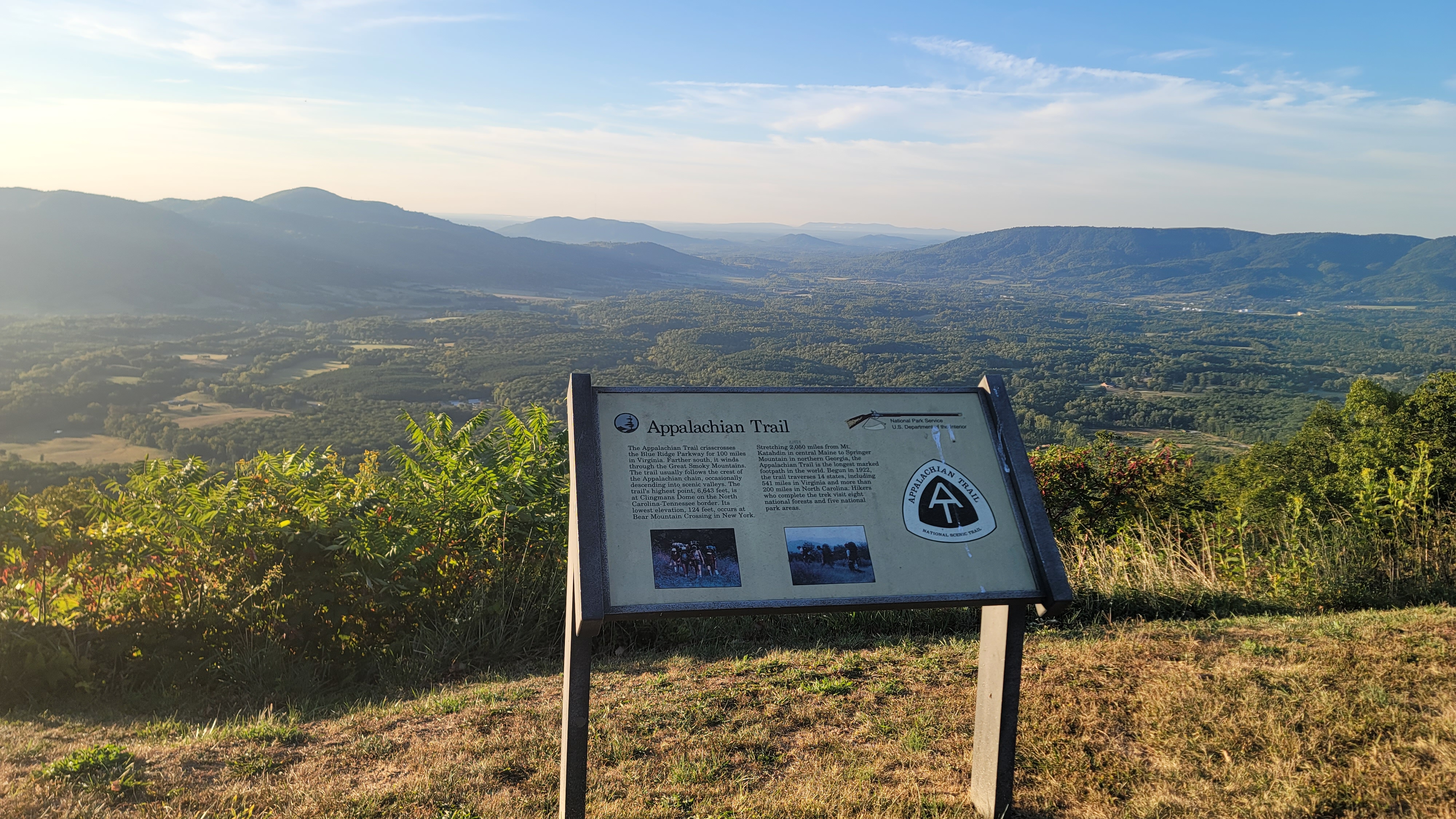
The views from the ridge are absolutely gorgeous. I love the southern perspective, as the mountain ridges stretch out as far as I can see. The trail here actually curves to the east and the south, so while I am making zero progress north, at least I can enjoy these wonderful views.
I stop at the Cove Mountain Shelter (mile 755.6), which is touted as one of the nicest shelters on the trail. Actually, the shelter itself is quite nice and clean. But it's the privy that draws the best reviews. I can count on one hand the number of times I have used a privy on the AT, but I am intrigued so I take a look and a picture. The privy is indeed very clean and has no odor whatsoever. But I'm still not using it!
I check and can't believe I have cell service so I call home and check in with my husband and let him know my plans. The cell service is almost nonexistent here, so we have been relying on my InReach to communicate via satellite. He can see where I am anywhere at anytime, as long as it is turned on and tracking is activated, which I am sure to do several times throughout the day, as well as when I set up camp at night.


I am salivating at the thought of my chicken gumbo tonight. I am so hungry that I take a few bites, but I have an 1100 foot climb over the next 1.2 miles, so to say the terrain is very steep is the understatement of the year. I don't want to do this elevation gain with a full stomach, so instead, I mix up a packet of matcha with some vanilla protein powder. I'm sure this is sacrilegious to tea aficionados, but I'm in the woods, so I can do what I want!
With a rehydrated dinner and a water-laden pack, my feet tingling from the cold water of the stream, I make my way back into the woods. Someone has thoughtfully left several bottles of water and a roll of toilet paper by the trail. I start very slowly up the hill. Thankfully the temperature has cooled to a delicious 75F degrees, and a breeze is blowing at my back.
 |
| A deer says "hello" |
By the light of my headlamp I get to the shelter, which is gorgeous. It looks new and clean with two full decks. I bet this place could sleep a dozen people, and I realize at least one person is indeed inside when I get closer. I shield the occupant from the light of my headlamp with my hand and look for a suitable spot to set up my hammock, but I realize quickly there isn't one here; the trees are too numerous and the ground beside the shelter very narrow. The camper in the shelter turns a headlamp on me, probably hearing me move about and thinking I am an animal. He murmurs an apology and I continue up the hill.
I'm thinking how tired I feel right now, and I would love to set up camp near the water source here. I survey the woods to my right and left as I continue up the trail from the shelter. The light of the headlamp doesn't penetrate far, but I can tell it's steep and thick. Thankfully I get to an intersection with another trail and find a good site for my tarp and hammock. I have to step over and stomp down some greenbriar, the thorns long and sharp, to keep from snagging my clothes and my quilts, but I make short work of it.
I get set up and gobble down some of my dinner, but I am so tired I really have to choke it down. I don't have the energy to bear bag, and even if I did I can't make out the tree branches in the black of night, so I hang my food bag in a tree away from my hammock.
I hiked almost 20 miles today, with almost 4,000 feet of elevation gain. No wonder I am so tired!!

Trail Stats: 764 Miles, 168K elevation gain
No comments :
Post a Comment