Nav Bar

About     ♦   Foraging     ♦   Backpacking     ♦   Trail Food    ♦   Wild@Home    ♦    Links    ♦   Demeter's Wild @ Home Store

Emergency Essentials/BePrepared

Appalachian Trail day 96 - Ed Garvey Shelter to Pine Knob Shelter - Maryland! (Mile 1033 to Mile 1049)

At some point after we went to bed it started raining.  I got up to water the leaves and the rain is steady but light. I try to creep out and back quietly, as there's about 10 people in the shelter between the two floors.

At 5 am,  GG and I are both up.  I try to pack as quietly as possible,  but it's kind of impossible to be absolutely quiet and there's nowhere else to pack because of the rain. A few more people wake up and start packing while we are doing so periods well.  The woman that we met on the way up the trail yesterday is in her sleeping bag, as is her friend, but they lift their heads up and tell us happy trails before we leave.  They are planning on only hiking four miles to the next shelter.  I give her words of encouragement, telling her she will be fine as long as she takes it really easy. We say goodbye and I am out the door by 6:07 am.

The first section of today's hike is super easy.  I've hiked this section so many times, I don't have to look at my map. Gathland State Park is a great stopping point for hikers .  In season there are real bathrooms and there's a water pump next to the bathroom for refilling water.  A big picnic pavilion is close to the bathroom that is reservation only, but serves as a great stopping area for hikers.  GG and I plan on rendezvousing at the park. 

Gathland State Park

Appalachian Trail day 95 - Keys Gap, WV to Ed Garvey Shelter - One More State with Gadget Girl! (Mile 1020 to Mile 1034)

I went home for a couple days.  A doctor confirms my suspicion and I am being treated for Lyme disease.  I feel great and I am ready for some more miles!

I am back hiking with my friend Gadget Girl (GG for short).  She is now back from her travels and ultra trail races and ready to hit the trail with me. GG has been with me since the beginning in Georgia.  She had obligations when I was able to hit the trail last September and this last month, but now she is available to hike with me, hopefully the entire way to Maine! 

We are dropped off at Keys Gap by BG, who is the most wonderful person.  We talked about podcasts on the way, and he mentions that he was on the Mighty Blue podcast with his son back in 2021 when he thru hiked.  I can't wait to hear it, and make a note to download it for trail listening.  

We aren't even on the trail before a gentleman asks if we'd like trail magic! He has already treated 6 thru hikers this morning! We explain that we're just starting, out so I decline the Powerade offer but I take a couple mini candy bars, as does GG, and we are on the trail minutes later.


Appalachian Trail Day 94 - Bear's Den Hostel to Keys Gap, WV - Get Me Off This Damn Rollercoaster! (Mile 1006 to Mile 1020)

I am the first one up this morning,  not surprising since I was the first one out last night. I quietly take two trips to carry all my belongings upstairs so I can pack without waking anyone. 

The hostel manager turns on the coffee maker in the kitchen. I'm making a cup of coffee and see a tent set up in the backyard that wasn't there the night before. The manager remarks that the camper probably wishes they slept inside last night, the storms were so wicked.  I didn't hear a thing, but I'm very thankful I stayed inside!

The manager tells me to mind one of the dogs roaming the hostel, because the Great Pyrenees thinks unattended socks are chew toys, then she proclaims she is going back to bed. 


I enjoy my coffee while packing, not in a hurry, but wanting an early start. Especially now that I'm suspicious of having caught Lyme disease,  and worrying I will be fatigued and slow making some miles.  Harper's Ferry is 20 miles north, and I need to get off the trail early tomorrow morning so I can get home before the doctor's office closes.  The traffic around Baltimore and Washington D.C. are bad on a good day, but the beach traffic going over the Bay Bridge on a Friday is off the charts. 

I am packed and ready to roll when I see Babysteps is up. She is also getting ready to leave so we walk out together and get a picture just before leaving the hostel. 

Appalachian Trail Day 93 - Rod Hollow Shelter to Bear's Den Hostel - A respite from the rain! (Mile 996 to Mile 1006)


I wake up this morning once again to the pitter patter of raindrops on the tarp. Darn, I was hoping this rain would have moved out while I was sleeping last night.  I slept surprisingly well last night. Sitting up, I survey the area surrounding my hammock, hoping it didn't flood during the night. My pack is where I left it, and the much puddles are neither no worse nor better than when I fell asleep.  

I start to put on my shoes and I see the fattest, longest yellow slug ever inside my hiking shoe.  Gross!  I am so glad I looked before I put my shoe on.  That could have been one disgusting mess!  I grimace as I pick the slug out of my shoes. I can't stand slugs.  The are so slimy and soft. I throw the offensive thing in the brush.  

I get up and start the slow process of packing up my belongings without getting everything more wet and muddy than they already are. I am picking slugs off everything that wasn't suspended on a tree last night!  They are on the ground pad, the umbrella, my backpack, and even the pee rag I used in the middle of the night. Ugh!

I take down the hammock first, putting the down top quilt into the stuff sack.  Unfortunately, the stuff sack that I use to store my hammock and down inside my pack is heavy with moisture from the humidity.  Thankfully I have an extra Walmart shopping bag in my pack,  so I wrap my down top quilt In the shopping bag before I put it in the wet stuff sack. I will have to devise a better way to keep my things dry. 

The hammock, quilts, and pillow go in first, in the bottom of the pack where I won't need them again until tonight.  Then, in no particular order, I throw in my stove, electronics bag, and camp clothes bag.  On top, I put my food, since I may need it during the day.  I already pulled out my food for today and put that in my waist pack, where I can access it easily while hiking. 

Right before I put away my tarp, I put on my wet and cold hiking clothes and then my rain gear with a couple quick intakes of breathe.  The rain is starting to end as I finish packing, but I'm chilly enough that the rain gear will provide a vapor barrier to conserve my body heat. 

I hop back onto the trail, drinking my breakfast shake as I hike.  I immediately come across a long, winding strip of the same little lumber bridges that I busted my butt on yesterday.  I choose to walk in the ankle deep water beside them, not wanting to take a chance on falling again.


Appalachian Trail Day 92 - Manassas Gap Shelter to Rod Hollow Shelter - No Pain, No Rain, No Maine (Mile 983 to Mile 996)

I wake up this morning to the pitter-pat of raindrops on my tarp. The weatherman was definitely not wrong on this one, unfortunately. I pack everything up under the protection of the tarp, making it the last thing I put in my pack. Even though everything was protected from the rain, it all feels damp to the touch, as it always does in the humid weather.


I head north on the trail by 7:30 am. It'll be slow going today in the rain, I am sure, but I will try to do my 15 miles regardless. 

I walk up and over a mountain and on the way I run into a section hiker followed by another one about 30 minutes later. One of them tells me that the next shelter was very full last night with thru hikers, and they were all going to try to get into town, except a couple were talking about staying there and taking a zero in the shelter.  The 4 miles to the shelter is uneventful; it's actually very easy hiking.  

I am so thrilled I brought my umbrella on this trip.  I almost left it in the truck but grabbed it at the last minuted.   I figure out a way to attach it through my sternum strap to my waist belt so that I can walk with my hands free and it doesn't move. It's a little bit close to the top of my head, but that's okay. 

The rain is so heavy at times I can't hear my audiobook through the phone speaker, so I wear my Shokz headphones.  I am now on the fourth book in the Red Rising saga.  A big 'thank you' to the hiker that recommended me this series so long ago!  This series has kept me company for the last two hundred miles!


I get to the intersection for the next shelter. I've been kind of struggling mentally with whether or not I want to go there. I would really like to get out of the rain for a few minutes and eat some lunch without worried about dropping anything on the wet ground. On the other hand, the shelter is 3/10 of a mile down the trail which means I would also have to walk the 3/10 of a mile back up. I really hate bonus miles, especially on rainy days. 

My desire to relax under the shelter roof wins out, and I descend on the blue blazed trail to Whiskey Hollow Shelter.  When I arrive, I see a young man inside who looks to be asleep in his sleeping bag, and I try to be very quiet when I ascend the stairs to the covered porch, but he lifts his head up. He was obviously not sleeping. We chat for a few minutes and I tell him I'm just getting out of the rain for a little while. He tells me he decided to zero here and then he lays his head back down again, oblivious to what I'm doing.  

I take off my backpack and pull out my food bag; I decided if I'm going to all this effort then I'm going to stay here for at least 30 minutes. This shelter is so nice. I've been here before. If you're going to zero at a shelter this is the place you want to do it.

I filter a couple liters of water and plan on drinking one with my lunch. I just enjoy being out of the driving rain for a little while. But I am cold since everything is saturated, so I take off my rain jacket and put on my down jacket for a few minutes over my sodden shirt. I pull every single thing out of my pack to get to my battery pack, but it will only take me a few minutes to stuff everything back in when I'm ready to go.


I see the longest earthworms I have ever seen in my life, and take a picture of my shoe next to one for scale.  I wear size 11 in women's shoes and this thing is longer than my foot!!


I look at my map and realize that I probably won't make it as far as I had hoped today. I know the next shelter is almost nine miles away. I think that will be a good stopping place. I kind of kick myself or not bringing a sleeping pad because as much as I hate sleeping in  a shelter, this sure would be a nice day to just hunker down in a place that has three walls and a roof. Especially because there's an inch of water on the ground everywhere I look.  

I remind myself that I'm okay with sleeping in the hammock and any conditions, and a little rain and mud won't hurt me, but when I leave the comfort of the shelter, I think of ways I can shave some weight from my pack in order to bring a sleeping pad with me in the future. 

Over the next five miles after Whiskey Hollow, I hike up an over some hills where there should be some views but I can't see 50 feet off the ridge. The highlight is Sky Meadows State Park, where the AT wanders through the western side of the park for quite some time, maybe two miles, on a lovely maintained and flat trail and forest road. The tulip poplar (Liriodendron tulipifera) are in full flower, and I the cup-shaped blooms litter the trail. 


The Trail In Sky Meadows State Park

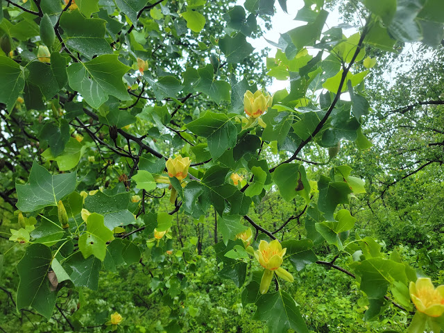
Tulip Poplars in Bloom

Leaving Sky Meadows, I cross US Route 50 at Ashby Gap, where I hike uphill some more and cross many streams, all of which are swollen and angry. I have absolutely no lack of water, and I can fill up my water about every mile. The only problem is with the downpour, all of the streams are dirty. There will be no clear water today. I really hope my filter doesn't get clogged with all the silt and debris.

I feel like I'm a pretty decent judge of time and distance on the trail, but with the rain (and having my head down) I'm a little disoriented. I feel like I should have been at the turnoff for Rod Hollow Shelter by now. The vegetation on both sides of the trail are collapsing into the trail like it hasn't been very well maintained.  

I keep brushing by spicebush (Lindera benzoin) and avoiding getting snagged on wild roses for the last half mile.  The smell is intoxicating, even in the rain, but maybe with my head down I accidentally made a wrong turn? I consult the map and I breathe a sigh of relief when I realize that I am indeed on the right trail and did not accidentally take the side trail..  It's just that the water is weighing all the vegetation down and making it choke the trail

The map says I'm actually very close and within a quarter of a mile I see the blue blaze. There are wooden lumber bridges of sorts, made by elevating some 2X6's off the ground with blocks of 4x4's. 

 Some of the boards look like they have been recently replaced and aren't very weathered. I take a step and immediately my feet fly out from under me and I go down hard on the bridge. I land really hard on my right hip and my right hand, which I hyperextend back in the process.  I sit there for a second, the wind knocked out of me by the fall.  I cautiously move my hand.  Nothing broken, thank goodness, but I'm going to ache tomorrow.  I get up gingerly, testing all my joints: nothing seriously injured. 

One of the many small streams

One of the Many Slick Bridges

I spy the turn off to the shelter shortly after my fall.  Just before the trail junction, I stop to take a quick video of the death traps.  I literally put one foot over the bridge to try to cross over to the other side where it was a little less muddy and my feet fly out from under me again!  I can't win. I'm just putting the phone away and going to stay in the mud where I'll get wet and muddy but not at least not kill myself in a fall.

I turn onto the blue-blazed trail to the shelter.  I cross a small stream that has swollen to the size of a very large swift stream with the rain.  I go up to the shelter and see there is one female occupant who has her tent set up in the middle of the shelter.  As soon as she sees me approach, she unzips her tent and jumps out,  moving her things which are spread all over the inside of the shelter to make room for me.  I  stand in the driving rain outside the shelter and I tell her not to bother because I am going to be sleeping in my hammock tonight. 


The Side Trail to Rod Hollow Shelter

I take off my pack and grab my umbrella to look around the shelter to see if there's a suitable site here to set up.  The picnic table is under cover of a roof, and it sure would be nice to sit here tonight and eat my dinner.  But I like the sites near the AT, closer to the raging torrent of a stream, so I shoulder my pack, say goodbye, and walk a short ways back up the trail.

I hang my tarp super high, so I can hang my hammock high as well and not have to worry about getting splashed with water at night. The trees that I pick are the perfect distance, but one is so big in circumference I worry my tree strap won't fit around it.  I let out the tree strap as far as it will go and it barely fits around the tree with only two inches to spare.

I get set up and make all of my adjustments to my tarp and hammock before I strip off my soaking wet clothes, put on my woolies including my wool socks.  Sitting on the side of my hammock like a chair, I heat up water on my stove under the cover of the tarp, careful to not get the stove too close to tarp or hammock.  I rehydrate my dinner, which is Peak Refuel Homestyle Chicken and Rice.  Which is as close to comfort food as I can get right now.  The rice is in a cheddar cheese sauce with big chunks of chicken.  This is my new favorite camp food for sure.  

My shoes are drenched, so when I have to get up and water the leaves at some point tonight, I will have to put on my soaking wet shoes.  Thankfully I have a couple of plastic shopping bags in the bottom of my pack.  I pull them out and tuck them inside of my hiking shoes, so when I get up my socks will stay dry.  

The good news is with the driving rain the critters won't be able to smell the food.  I get up and hang my food bag on nearby tree and tuck in for the night.  The time is only 7:20 p.m, but I am wiped out and I quickly fall asleep. 


Everything Under the Tarp, Finally Out of the Rain


Laying in the Hammock and Ready For Bed

Today's Stats: 13.3 Miles, 2031 feet gain, 2887 feet loss
Trail Stats: 996 Miles, 219K feet gain, 224K feet loss

Appalachian Trail Day 91 - VA Route 522 to Manasses Gap Shelter - Where Are All The Hikers? (Mile 972-Mile 983)

Back on the trail again! I was off the trail for the weekend, but I feel like it was so much longer. I definitely needed the time off for sure. My hips have been really hurting me, and my body needed a break from walking day in and day out. I arranged a shuttle with BG, a friend of Preacherman Wayne's, is meeting me. I Go to the ATC in Harpers Ferry and get my backpacking tag.  There are several thru-hikers checking in and a new flip-flopper registering when I arrive.  I look the hiker yearbook and see Non-Stop and Buttercup's picture!

 I Meet BG at the Harpers Ferry National Historic Park Visitor Center. The fee booth is closed because the town of Harpers Ferry is having work done on the water main and there's no water, so I guess they're not charging anyone for entrance. I scored on that one! BG Seems so nice, just like his Waynesboro counterpart Wayne. We chat the entire trip to Front Royal.  He thru-hiked in 2021 and he tells me about his adventures.  The trip takes no time at all and he drops me off and I'm on my way around noon. 


There is heavy rain in the forecast for the next few days, and it looks like I will get rained on at some point today, so I'm going to just get as far as I can before it gets full dark.  The heavy rain is supposed to start tomorrow morning.  The weather is nice, the temp is 77 degrees and it's overcast.  Leaving 522, the trail heads immediately uphill.  

The trail runs along the side of property owned by the Smithsonian Institute. This property is massively huge.  Chain link fence topped with barbed wire runs the whole length of the property.  I hike alongside of it for at least a mile. 

I pass by some trail magic on the side of the trail.  My pack is stuffed with food, so I don't take anything.  I would hate to deprive someone behind me a nice snack.

I feel like I'm really dragging, but after an hour I see that I was able to do two miles, even with hiking uphill the entire way.  I also have a pack full of food and water, and with the warm temperature, I think 2 mph is pretty good.  


After the hill, the hike is actually very easy for the next couple miles.  I stop at the Jim and Molly Denton shelter at mile 977 for water.  My new water filter is working beautifully, but I realize the water bag doesn't connect very well, and it is leaking like crazy at the connection, so I'm dumping about half of the same amount of water that I'm filtering onto the ground. I have to angle it so that the dirty water from the bag doesn't leak into my clean water that I filter and contaminate it with nasty protozoa.  Giardia is a real problem on the trail! 

The poison ivy here is so freaking huge, and crazy thick on both sides of the trail.  I take care not to touch any while shouldering my pack after I filter water. 

I walk over to the nearby shelter.  I stayed here once before when doing a section hike with my friend Becky.  This spot is just as lovely as I remembered.  A large covered picnic area is off to the side of the shelter, which features a nice huge deck. Horseshoe pits are out front of the shelter on the grassy lawn, and there is even a shower that runs off of the spring nearby. Unfortunately, the spring is almost dry and supposedly the shower hasn't worked in some time, but I don't try it out, and there's no one here to ask. 

I look through the shelter log, and I see an entry from Babysteps! She made it here a few days before and is doing really well. She's making great time and she talks about how she can't wait to be in her husband's loving arms, LOL. He's meeting her in Harpers Ferry next weekend.  She also has a post script to Goldilocks. I'm wondering if she means me, because the group at Open Arms were joking that should be my trail name since I need everything to be just right in order to sleep.  

I should have taken a picture of the entry.  She said If I'm reading this I'm back on the trail and I'm meant to be here.  I really hope I can catch up with her at some point.  Maybe I will if she stays a few days in Harpers Ferry.  

I start feeling occasional raindrops as I return to the trail. The next shelter is five and a half miles and it's only 2:30, so I think I can get there well before dark. If not, I can always set up camp where ever I find a suitable spot. 


The trail is really nice, albeit narrow from the thick vegetation on both sides.  The trail is flat and covered with pine sheds interspersed with short rocky areas.  I cross a road and hike into a really cool meadow that goes up the hill.   The meadow is thick with Autumn Olives and black briar canes. The smell of the passiflora rose has been absolutely divine.  I have been walking through a rose scented tunnel for the last six and a half miles.

The trail goes up and down and I emerge into another meadow, although this one is more  briar and poison ivy chaos than a field type of meadow.  I have to mind the poison ivy as I walk on the trail because it is inches from my ankles.  The milkweed is plentiful, which is wonderful for Monarch butterflies,  and lots of mountain mint line the trail.  I'm sure the bees and butterflies go wild around here in the summertime.


I'm sitting on a random bench in the meadow for just a second when a thru hiker comes through followed shortly by his wife.  They are trying to make some miles so they can take a zero tomorrow with the heavy rain in the forecast.  He says one to two inches are expected tomorrow. I think I will be quite soggy by tomorrow night!

I re-enter the woods and start downhill.  I can hear the road noise of I-66 not too far in the distance. It increases in intensity as I descend. Soon I am crossing a road and I walk down a country lane that goes under the interstate before the white blazes take me over a stream and then uphill once again.


I've been hiking up for what seems like forever, but soon I have covered an additional 2.5 miles, when I reach the blue blaze for Manassas Gap shelter. 

When I arrive at the shelter there is one occupant, a nice lady a little older than me.  We chat for a few minutes before I grab some water and walk back up the trail to try to find a suitable spot for my hammock. I end up setting up near the AT before I go back to the shelter to eat my dinner at the picnic table and talk to the woman at the shelter.  She is doing long sections and hoping to go southbound to Georgia. 

I finish my dinner just has big, fat raindrops start to fall.  I say good night and get in my hammock. I have cell service so I can call home and I work on my journal.


Todays Stats: 11 miles, 2520 elevation gain, 1788 feet loss
Trail Stats: 983 Miles, 217K feet gain, 221K feet loss

Appalachian Trail Day 90- Elkwallow Wayside to Front Royal - Goodbye Shenandoah and So Long Martian (Mile 953 to Mile 972)

I wake up at my usual time even though I slept just awfully last night.  I tossed and turned, and was hot and cold.  I start packing quickly and within a few minutes I hear an alarm and stirring from the room next door where Martian and Babysteps are staying.

I strip my bed and carry my pack and the used linen downstairs. Ms. Allison is half-awake in the laundry room in her robe.  She asks if I would like some coffee which I answer in the affirmative.  She hits the button on the coffee maker and I go outside to finish some last minute adjustments to my pack.

Baby Steps, Martian, Humble and me are all leaving the hostel for the trail today. Baby Steps and I check out the pin map that Miss Allison has. There is a pin in the map for each hiker that she has hosted over the years. There are so many pins in some places, in fact, that she has a separate map below the big one, so we add our contributions.