Nav Bar

About     ♦   Foraging     ♦   Backpacking     ♦   Trail Food    ♦   Wild@Home    ♦    Links    ♦   Demeter's Wild @ Home Store

Emergency Essentials/BePrepared

Appalachian Trail Day 48 - Elk Garden, VA to Wise Shelter - Ice, Mud, and the Highest Views in Virginia (Mile 495 to Mile 504)

We are up before dawn.  Last night the time sprang forward for Daylight Savings Time, so we lost an hour, but we went to bed so early that we both had plenty of sleep.  We check the weather, and just as predicted, the weather up on Mount Rogers is a balmy -15F with the windchill.  It will be around -10F when we set off in an hour or so, but at least it will be sunny and warmer later today, getting up to 40F this afternoon as the high-pressure system starts to move through. I privately give thanks to the inventor of hand and toe warmers, of which we both are carrying large amounts. 


We load our packs into the truck, grab large cups of fresh hot coffee from the store, and settle our bill with Paula.  This place is a wonderful respite from the trail, and I thank Paula profusely for her hospitality and promise to leave a positive online review. 

We drive back to Cole's place, where we park the truck, and we pile in for the return trip to Elk Garden, our winter gloves, hats, and hand warmers at the ready.  We admire the wintry landscape on the drive up.  The light dusting of ice and snow makes the trees and grass sparkle in the dim morning light, and the landscape becomes more arctic looking as we gain elevation.  I also admire how confidently people in the mountains drive on twisting roads, while I hold onto the door handle to prevent being jostled by the pitch. We arrive at the parking lot and say our goodbyes as we pay him for the trip. The next time we see him will be when we hike into Troutdale after we complete the highlands. 


Getting out of the car we are hit by icy blasts of wind and I run behind the small building housing a pit toilet to get out of the gale while I put on my winter mittens and hat before hoisting my pack.  I am wearing a ridiculous looking but extremely warm bright orange rabbit fur-lined bomber hat that fastens under my chin.  This hat accompanies me on any trip under 30 degrees.  Absurd as it may look, this thing is amazing in this kind of weather. 

GG is already moving up the trail from the parking lot when I step out from behind the shelter, and I hurry not only to catch up, but to stay warm.  We fumble with the livestock gate that keeps the resident cows and ponies off the road. The temperature is 21F with 30 mph sustained winds and gusts that make us sidestep as we hike up the hill toward Mount Rogers.  The wind is directly in our faces as we hike up a grassy bald devoid of trees to block the wind.  The windchill is 2F, and with the gusts, drops below 0. 

We wear our buffs over our lower face, but within minutes my face is numb from the cold, the wind biting at the exposed skin between buff and hat. My face is already chapped from the wind and rain coming up Whitetop, and I smeared Aquaphor on my cheeks and nose earlier, hoping to prevent additional windburn. 

We make it to some brush on the edge of the woods after 30 minutes, but it feels like it took much longer.  The scraggly buckthorn helps a little to block the wind, but not really enough to matter. I can tell GG is really struggling with the cold.  I tell her we need to be honest with each other, and if our hands or feet get cold or we start getting concerned about our welfare we need to stop and deploy the tarp, where we can shelter in place from the wind in our down until it warms up. She states she doesn't need to do that and wants to keep going.  I admonish her that this isn't just hypothermia inducing cold, but we are entering frostbite territory. 


Thankfully we get to a trail junction and stop to heed the call of nature and decide we are both doing well enough to continue on our hike. The wind has abated a fair amount in the trees, but we still keep our heads down and follow the path underfoot.  I look up briefly and spy a blue blaze on a tree. Oh man, we are off the trail!  When did this happen? I turn on GPS and with relief see we are only a couple hundred yards off course. 

We backtrack and see the AT turned right while this trail continued straightforward off the AT, an easy enough mistake. Back on the right trail, with white blazes guiding us, we continue to climb upward. 

Shortly after, we encounter three young men heading the opposite direction.  As they pull up in front of us, we exchange hellos, and I ask if they camped out last night. They reply in the affirmative and explain they are from Vermont on spring break. They came here thinking it would be significantly warmer this far south! They stayed in the shelter near the summit, and one of them forgot his sleeping pad in the car and didn't discover the mistake until they reached the shelter late last night. Happily, he survived the night with his digits intact.  


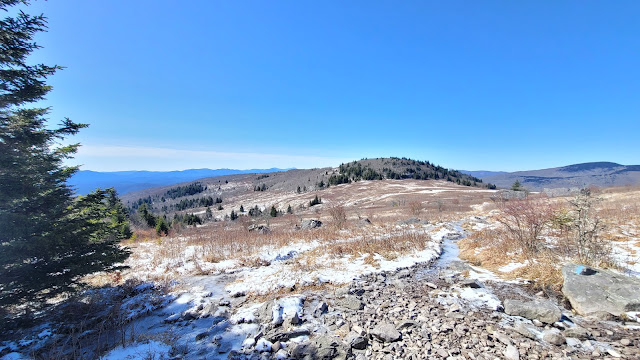
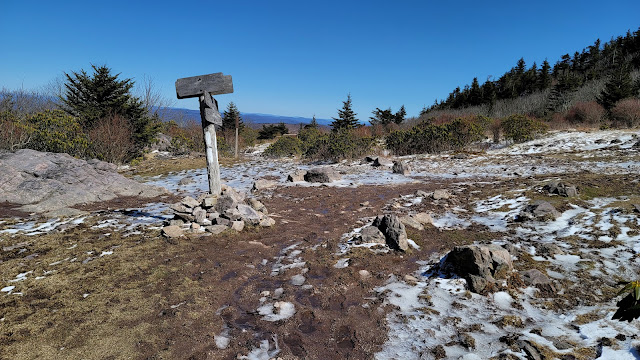
The sun is rising, slowly warming the air but the wind remains blustery cold. We walk gingerly and focus on the ground, because ice is abundant.  The beautiful crystals of ice rime pokes up out of the ground.  The views are outstanding as we stop to admire the landscape from the highest mountain since Roan in North Carolina. The surrounding mountain ridges stand in stark relief against the crisp blue sky.  


We stop at the Thomas Knob Shelter and eat lunch, talking to several other hikers seeking a brief shelter from the wind, then head north where we cross the 500-mile mark!  Actually, we don't realize we crossed it until we stopped for a pit stop and looked at the map. We high five and take in the gorgeous views, looking out for the famous pony herds while we dodge piles of horse dung. The ponies normally roam the highlands, but they are obviously smarter than we are for not being at 5,000 feet of elevation in this weather.


The next four miles is mostly open balds interspersed with stands of stubby spruce trees.  The sun warms the ground of the balds and melts the ice into deep and wide muddy puddles, which we have to step around to avoid the ankle-deep muck.  We also must tread carefully around the trees, where the mud gives way to treacherous patches of ice.  I get complacent and take a fall, landing painfully on my right hip.  Ouch! We wind around huge rocks where I take two more falls, landing on the same place.  I need to be more careful. We are already walking incredibly slow because of the conditions. 


We are alert for ponies as we enter Grayson Highlands State Park near Massie Gap, where they are routinely found. Unfortunately, not a pony in sight, although we see a lot of fresh manure.  We do pass a lot of day hikers and many backpackers who look woefully underprepared for the temperature. We find a coat on the ground, which probably fell off of someone's backpack. We have no idea which direction the hiker was traveling when they dropped the coat, so we hang it from a blueberry bush next to the trail.  Hopefully it was a day hiker that will be able to pick it up on their return. Yet another reason not to hang stuff from your pack! 


We arrive at Wise Shelter at 4 pm, absolutely spent from the cold.  It took 8 hours to hike 9 miles because of the hazardous trail conditions.  We both plan on sleeping in the shelter tonight, since the temperatures will dip to 25F, and the winds are still brisk. 

Two spring breakers are already set up in the shelter, and we talk while we set up our sleeping spaces and make dinner. One of them said they dropped their coat, but uncertain where.  GG and I look at each other with chagrin, as we explain that it's on the other side of Massie Gap, hanging on a blueberry bush. 

I heat water on my small gas canister stove to pour into a Nalgene so I will have a nice hot water bottle to warm my bed.  We go to bed shortly after sunset and prepare for a cold, cold night.  I am wearing every one of my layers to bed, with my wool base layer covered by a down layer, topped with my rain gear for extra insulation. I even have my bomber hat on over my buff.  

Today's Stats: 9 miles, 1519' ascent, 1647' descent

Trail Stats: 504 miles, 120k ascent


Appalachian Trail Day 47 - Lost Mountain Shelter to Elk Garden - A Refuge from the Tempest (Mile 487 to Mile 495)

 Last night was wild. The 40-mph wind howled all night, the rain beat heavily on the roof of the shelter, and the coyotes yipped like crazy from all sides of the shelter, adding to the cacophony.  At least a tree didn't fall on top of us. GG slept like the dead and heard none of it. I was not as fortunate. 

We pack up, steeling ourselves for the hike in this torrent. The rain is still coming down in sheets, and we are both so thankful for the nice dry shelter, but we need to meet Cole by 2:30 pm at Elk Garden.  At least we will be warm and dry tonight!  


The first mile is deliciously flat, and the trees give us some protection from the wind and rain, which has stopped for a moment.  Very shortly the trail starts to angle upward toward Whitetop.  The slope is manageable, but the wind is in our faces as we gain ascend.  The trees keep decreasing in height as we increase in elevation, and soon the only protection from the elements are the twisted and stooped buckthorns. 

For just a moment before we completely leave the trees for Buzzard Rock, the rain abates and becomes mist again.  We shelter from the wind behind some big rocks and grab a quick snack and laugh at our situation.  This isn't the first time we encountered crazy weather on Whitetop.  In 2020, when we hiked into Damascus from Mount Rogers, we camped on the northeast side of Whitetop.  The view from the hill in front of the parking area that night was absolutely breathtaking. A storm rolled in that night. The next morning, we left our camp set up while we hiked to Mount Rogers, also in the rain, but had to abort the hike because the temps dropped suddenly to 24F and the winds barreled in from the north, and the rain turned to snow and sleet. We returned to our camp to find inches of ice pellets and snow covering our gear.  We were freezing by the time we packed our camp and literally ran southward down the mountain seeking shelter.  By the time we reached Buzzard Rocks, the weather miraculously cleared, and the sun came out and we actually enjoyed some great views!


We are in good spirits as we continue up Whitetop, even though the rain resumes and stings our faces as we hike. We can't see a thing, since the fog is so thick the visibility is zero. We can see about 50 feet in front of us. Thank goodness we had amazing views (albeit briefly) the last time we hiked this area.  

The heavy rain starts again as we cross the forest road to Whitetop, and we once again enter cover of trees.  The trail is moss covered and years of hikers walking over the same path has eroded the dirt off the rocks underneath, making for tricky footing.  The runoff from the heavy rain takes the path of least resistance, which is the trail.  Slippery, moss-covered rocks and ankle-deep water running down the trail slows our pace.   I am so thankful for my neoprene socks, which don't keep my feet from getting wet, but are wonderful at conserving my heat and keeping my feet nice and warm. 

Even in the pouring rain and high winds, I love hiking through these woods.  We walk under shelter of thick pine and spruce trees moss and twisted rhododendron are .  The smell is divine as ever.


At 2:05 pm, one hour after leaving Whitetop, we near VA 600, and a few minutes later we are loading our things in the back of Coles car.  He arrived 30 minutes early, so we won't have to wait in the rain!  What a sweetie.  I was fully prepared to set up my tarp to protect us while we waited for him, even carrying it on the top of my pack.  He says he has to keep us alive so we can pay him, ha-ha.  I give him a generous tip, because he really saved our bacon today! He drives us back to his house, where I pick up my truck.  

30 minutes later we arrive at Grayson Highlands Store, and check in, where Paula (the owner) shows us to our room above the store.  We start laundry and take showers, exploding our packs all over the spacious room so our wet stuff can dry out.  We have to leave a path open so we can walk to the bathroom without tripping!


We go downstairs and order from the grill and I enjoy the most delicious cheeseburger and fries of my life.  We retire back to our room, where GG has the bed, and I have a roll-away between the dresser and the closet.  I check the weather and as expected, the temps on Mount Rogers are diving to -20F windchill with sustained winds of 40mph and gusts of 65mph. We are so thankful for the roof over our heads and the amazing food!  

Today's Stats: 8.6 miles, 2500 feet gain

Trail Stats: 495 Miles, 117K elevation gain


Appalachian Trail Day 46 - Saunders Shelter to Lost Mountain Shelter - Howling Wind, Driving Rain, and Yipping Coyotes! (Mile 480.5 to Mile 487)

 We went to bed so early last night that I found myself wide awake at 3 am. The wind picked up and the noise must have awakened me.  I lost my earplugs in my bedding last night; I frequently pull them out in my sleep and then have to hunt for them later.   I burrow into my downy warmness to read for a while, then fall back asleep.  Anticipating single-digit temps at night, I brought down pants in addition to my Feathered Friends down booties and a down coat, and I am happy to report that this should be sufficient to keep my warm during this section. I woke up just in time to watch the sun peek over the ridge and through the trees.  GG is up already as evident by the glow from her headlamp illuminating the inside of her tent. 

Camping behind Saunders Shelter

Appalachian Trail Day 45 - Damascus to Saunders Shelter - Back on the Trail! ( Mile 471 to Mile 480.5)

GG and I came back to the trail after a long hiatus: it's been nine long months since we were last in Damascus. We arrived in town yesterday evening. We are staying at the iconic Broken Fiddle which just opened for the season last week. We checked in to discover that we are sharing the hostel with a thru hiker who started in January! He is thru-hiker number 38 (all the thru-hikers receive a tag with their trail number on it when they start in Georgia).


Appalachian Trail Day 44 - Campsite to Damascus, VA - 3 Down, 11 To Go (Mile 464 to Mile 471)

We were all up by 7 am.   I had bizarre dreams about being trapped at work that were so strange, I am thankful I can get up and so I can stop dreaming this nonsense.  The temperature last night was almost too warm for sleeping comfortably and I had to kick off my top quilt several times. Were I not going home, I would send back either my sleeping pad or my underquilt after the Grayson Highlands just north of Damascus. Most hikers send back their colder weather gear before Damascus, but I have hiked enough to know that the Highlands can be brutally cold.  

The sun is shining as we break down camp, and a steady 15 mph breeze makes me shiver and pile on the layers up here on the ridge. I welcome the stiff wind since biting flies won't be able to dive-bomb me today.  I am scratching furiously because I was bombarded last night by black flies.  First, they attacked the back of my legs, face, and neck once we arrived in camp, then, once I donned my leggings they zeroed in on my ankles, on the small bit of skin showing between my socks and my leggings.  I also have several bites on the inside of my wrist, on the area between my long sleeves and fingerless gloves. I rarely feel the suckers when they bite, but the next morning the itching is enough to drive me mad.  I just have to make it to town, where I can buy some calamine lotion.  For now, I grind up some aspirin and apply it topically, which provides a little relief. 

Appalachian Trail Day 43 - Double Spring Shelter to Campsite - Very Beary (Mile 452.5 to Mile 464)

 I slept fitfully last night, probably because I kept having dreams of something crashing on top of me while in my hammock.  I was surprisingly comfortable with my legs elevated.  My legs feel better from it this morning: the dependent edema from hiking is a constant out here.   For the last hour of sleep, every time I would think I needed to get up I would close my eyes and go back into a dream.  GG wakes me up by asking me to come get the food bag out of the tree, because it's stuck.  I ask if there is anyone awake at the shelter who can help, because I'm not ready to get up. She replies they are still sleeping, so I roll out of my hammock and rub the sleep from my eyes. 

Appalachian Trail Day 42 - Ridgetop Campsite to Double Spring Shelter - Hello Friend! (Mile 441.5 to Mile 452.5)

We had an uneventful night last night, thank goodness!  No bears in camp, and our food remained unmolested.  I woke briefly to realize the foot end of my hammock was hung a smidge too low and as a result, my body slid enough for my feet to be touching the end of the hammock.  I briefly thought to myself "I should get up and fix this," but rolled over and went straight back to sleep.  And I slept so well.  The temperature is about 50 degrees on the ridge with no wind. 

GG is already up and packed and enjoying breakfast while I get my life together.  Thankfully we have nowhere to be and nothing to do but hike.  We have no agenda: we will decide where to stop when we feel like stopping.  Total and utter freedom. 

We collect extra water since the next two water sources are described in app as "take a 200-foot side trail to a water source."  That is code for "you will have to walk a hell of a long ways down off the trail and then hike back up with your heavy water bladder."