

We wake, pack our things, and make a cup of coffee before returning to Kent to continue our trek. For once, everyone in the hostel is up as early as we are, so we don't worry about waking the other occupants while we pepare for our departure. The sun is rising as we pack.

I leave my truck here in Salisbury, where we plan on returning within a few days. This next section from Kent to Salisbury is only 34 miles, but with more than 7,000 feet of vertical gain, we are packing three days of food. I feel good this morning, but that's a lot of vertical in this heat, especially with full packs. I plan on chugging lots of water and eating tons of salty snacks for the forecasted 90°+ of the next two days.
We drive back to Kent and we are on the trail by 8:20. We are only a hundred yards from the car when I look behind and see a figure walking towards us. I can't make out the person, but I recognize the bright pink top and day-glo yellow shorts. Zen is behind us, and Kelly and I wait for them to catch up.
We chat for the brief roadwalk, and we say goodbye to Zen and follow the trail back into the woods. Zen continues into Kent proper, where the visitor center offers showers to thru hikers. Apparently the townsfolk got sick of the hikers stinking up the establishments, so they entice hikers to clean up first.
The climb out of Kent is steep and makes me work hard to breathe for the first mile. I am feeling well and make the hike up without stopping; a good potent for the day to come. The weather is perfect, with a temperature of 75°, and the sunny blue sky overhead has a few clouds floating by.
We are always picking up small bits of trash on the trail, but I always draw the line at paper products because I don't know what body parts it may have touched. Of course, in this case it's obvious where this paper has been, so we leave it just the same.

Just beyond the mess is Caleb's Peak, an overlook with beautiful views of the Housatonic River down in the valley below. Two women are at the top with a gorgeous Aussie shepard. We chat for a few minutes and start to walk away when two young men walk past and tell us to have a good time in Kent. Wait! What? I reply that we are northbound and that's when we realize we are headed in the wrong direction. I'm so glad they said that, or we may have gone way more than a few feet out of the way!

Less than a mile of easy ridge walking later the trail continues to another beautiful overlook called Saint John's Ledges, where we are treated to some more gorgeous views to the east. The views aren't expansive today, but we are really enjoying them nonetheless.
Leaving Saint John's Ledges the trail descends abruptly and we rapidly lose 600 feet with a half-mile of knee-jarring, big rock steps. The descent is really slow due to the size of some of the rocks. I plant each pole firmly, move one foot down, then reach with a pole further down before planting the other foot. I frequently think that if a pole gives out that i will tumble head over teakettle and be waking up in an ICU somewhere in rural Connecticut, and I am grateful when we make it down without incident.

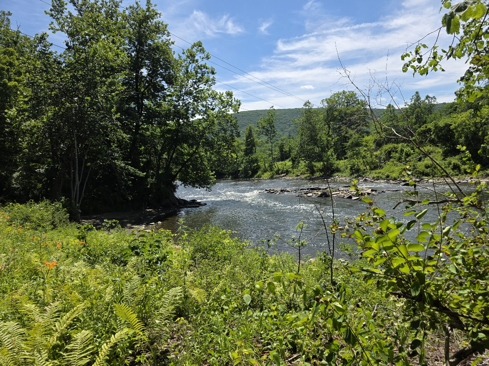
Once we reach flat ground, the trail follows a gravel road that parallels the Housatonic River for three blissfully flat miles. The gorgeous walk is elevated by the delightful weather. A light breeze riffles the leaves of the oak trees overhead.
Families are picnicking along the other side of the river; the shrieks of people playing in the water and the mouth-watering smells of barbecue reach across the wide expanse. I fantasize that we will walk by one of these groups and they will ask us to join them, but alas, no one is on this side of the river but us hungry hikers.
Instead of a nice hot dog or hamburger, we stop for a break at Stony Brook Creek, which has beautiful clear cold water cascading down to the river, and we soak our feet in the stream while eating our lunch. A man walks by who looks familiar. I ask his name and he says "Late Start."

He says he remembers us as well, but we can't remember when we met. Then it hits me that we met him back at Delaware Water Gap almost two weeks ago. We chat about the heat and the amazingly beautiful trail here, and he says goodbye as we finish our snack.

As soon as my feet are so numb that I can't feel my toes, I get out and dolefully replace my damp sweaty socks and my even sweatier shoes. I would love to relax by the pretty stream for the remainder of the day, but it's time to get moving. Fortunately the soak in the icy water was very exhilarating, and we still have two miles of this beautiful river walk before we start climbing again.

The climb up is slow but steady, as the temperature is rather hot without a breeze on this side of the ridge. As we near the crest, the trail makes a sharp ascent on some rocks that require a little scrambling, but nothing too crazy, thankfully!
Once we summit the ridge we are rewarded with the most welcome breeze. The vista is not that great but the gentle wind is heaven-sent and worth all the effort that it took to get here. We stand in the shade for ten minutes and I am comfortably chilled by the time we leave the viewpoint.
What goes up must come down and as soon as we cross the ridge we start down quite steeply and the trail travels over smooth rocks that would be a nightmare in the rain. I'm glad that today is sunny, even though it's too hot. From the whipsaw elevation changes, we are obviously ridge hopping today
At the bottom the trail crosses Connecticut Route 4 which leads to the town of Cornwall Bridge a few miles away. We cross over the road and a sign is posted that this creek crossing is extremely dangerous after periods of heavy rain. Photos demonstrate how to safely cross the stream during high water, and a map highlights a road walk that curcumnavigates the stream altogether if necessary.

As we approach the stream, I see a man laying in the water, submerged up to his neck. It's Tad, and he says hello as we approach.
We are fortunate that the rocks to cross the stream are not submerged, as is often the case, as the FarOut comments report. We easily rock step across it.

Earthstar Is sitting on some rocks on the other side and we stop to talk to Earthstar as Tad gets out of the water. Right now Kelly and I are shooting for the next campsite which is only 2 miles and 700 feet of elevation away. We will decide when we get there if that's where we're stopping for the night or if we're going to continue on.
Kelly and I head up the next ridge from the stream and a short time later Tad and Earthstar catch up to us and we hike together for the next couple miles. Tad tells me his name is short for "The Amazing Dad."
We go on to discuss how the state of Connecticut forbades us from camping anywhere other than a designated campsite, but many of these campsites are loaded with huge dead trees that could kill someone without notice. Tad mentions that he ran into a ridge runner at the last shelter and complained about the number of widowmakers scattered throughout the camping area. The ridge runner basically shrugged their shoulders and said there was nothing they could do. I suggest to Tad that he send letters to the higher-ups. If someone gets injured at least it's a paper trail saying that they were aware of the danger.
We arrive at the campsite and Kelly and I decided this is a great place to stop for the night. If we continue to the shelter it's only another 3 miles, but it is an additional 1,500 ft of climbing, and while we are in good spirits, we would like to stop here. There's a beautiful stream nearby for water, and large flat sites for a tent, even though there are a great number of dead trees throughout.
We start setting up as Tad and Earthstar have a snack. They say goodbye and say they are heading to the shelter, where many of the dead trees were recently cut down. We are happy to be staying here tonight, and are thrilled to be in camp and set up before 5:00 p.m. for once.

I go down to the stream and sponge off in the cool clear water and Kelly and I sit on some rocks and enjoy a leisurely dinner. We discuss our plans for tomorrow and then put away our food bag and bear can in the provided bear box. The mosquitoes are now coming out in force so we retire to our camps which are right next to one another
I am enjoying laying in my hammock and just being still. The temperature is too hot for my top quilt, but I am comfortable in my sleeping shorts and T-shirt. For the next 2 hours we chat from the comfort of our bug-net protected camps and send each other pictures and discuss our intentions for the rest of our hike.
The weather forecast is for a high chance of rain starting tomorrow night, and Kelly expresses her concern about the hike down to Salisbury. The elevation profile shows a precariously step descent, but we have no idea whether or not it's rocky or dirt; we have encountered enough slippery rock slopes at this point to be worried. I am too tired to think on it further, and I say goodnight just as the light starts to dim the woods. I put on my earplugs and pull my buff down over my eyes.
Today's Stats: 13.2 miles, 3,100 feet gain
Trail Stats: 1,487 miles, 289K feet gain
No comments :
Post a Comment