We woke before dawn after a fitful night's sleep. No coyotes howled, fortunately, however the wind was wicked. Every time I started to drift off into a nice, deep sleep, Bam! The wind would blast in through the front of the shelter. Nothing like a cold face full of wind to wake one up. I think I woke up at least 20 times last night. The temperature is so cold that I make breakfast and hot tea and get back in my down to enjoy it.
 |
| Snug in my bed inside Wise Shelter |
I walk around the edge of the clearing and I witness the sun rise over the next ridge we will hike up this morning. We take our time packing up, waiting for the temp to warm before we head out when I look at my watch and I'm shocked to see it's almost 9 am! Daylight Savings Time is really screwing us up. At least we will have an extra hour of light to hike this evening. GG is still packing, but I am getting cold, so I tell her I am heading out and will wait up the trail once I warm up.
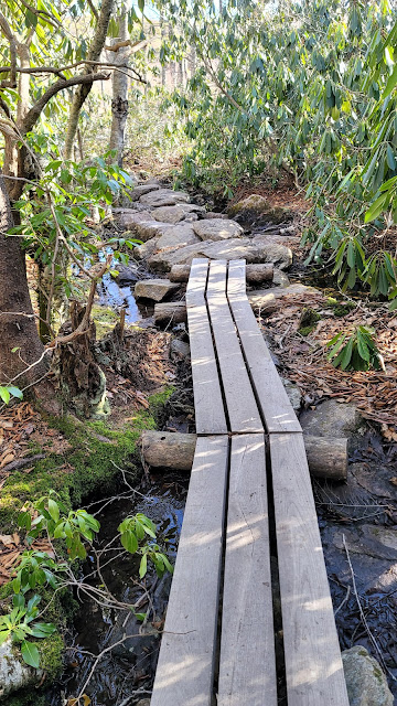
Just one-tenth of a mile down the trail is Big Wilson Creek; a beautiful narrow stream swollen with the recent runoff, surrounded by thick rhododendron. I cross over the rushing torrent via a sturdy bridge. This would be a beautiful spot to make camp, but within park boundaries camping is only allowed near the AT at developed campsites near the shelters.
Within a half mile the trail jaunts to the south, and the trees part enough for sunlight to warm the trail but still provide great protection from the wind. I take off my pack and enjoy the warmth while I wait for GG. She arrives a short time later and we head off together, leaving Grayson Highlands State Park
Most shelters are built in sheltered low-lying gaps between mountains, accessible by forest roads. Therefore, predictably, a hiker usually has a downhill hike into a shelter only to climb a mountain the following morning when leaving. I usually detest hiking uphill first thing in the morning, but this morning I look forward to the climb because I know the exertion will quickly warm me.
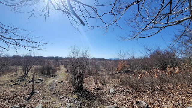
We shed layers on the way up and get nice and toasty warm. The sun is delightful, and I even start to sweat considerably. I am down to my wool top when we break tree line to emerge onto a bald. Oh boy is it frigid! The gale is considerable, and I am bone-numbingly cold by the time I take off my pack and throw all my layers back on again.
We walk for a mile northerly on a ridge that parallels the ridge we walked yesterday, but in the opposite direction. We have basically walked in a big horseshoe. This ridge is slightly east and lower in elevation, and as ever I relish looking at what we already hiked, but from a different vantage point. We are on the lookout for ponies. GG will be terribly disappointed if we don't see any.
The day is positively gorgeous, frosty temperature and blustery wind notwithstanding. I am so thankful we are blessed with two clear days to enjoy this area, which is my favorite of the entire trail so far. The views are beyond beautiful.
The descent off the ridge is bittersweet. I love that we are making forward progress, but the chance that I will return to this area for some time is slim. This is an 8-hour drive from my home, and I have a one-track mind when it comes to throwing all my spare time to completing this trail, which at our current rate will be in 7 or 8 years!
We arrive at The Scales, so named because cattle ranchers who grazed their cattle in the highlands during the summers of yore would weigh the cattle here before they began the long trek down to the valley, during which the cattle would undoubtedly lose weight. A large fence surrounds a pit toilet and fire pits. While the fence is used to round up the wild herds for wellness checks, the remainder of the year the fence serves not to keep livestock in, but to protect campers from feral ponies and cattle incursions. While cute, the ponies have been known to plow through campsites, trampling tents in search of yummy treats.
The trail runs straight through the fenced enclosure. As we approach the fence, I look over my shoulder and see ponies!! We drop our packs and make our way over to the five sturdy ponies unperturbably grazing on the short brown grass, their fluffy winter coats protecting them from the cold. We take some pictures, now content to leave the frigid highlands for warmer weather down in the valley.
We return to the shelter of trees and shed layers once again, relishing the warmth. The temperature reaches 55 degrees, and you'd think we'd died and gone to heaven. We climb a short ridge dense with moss-covered boulders and stunted spruce thickets. As we crest the ridge, we pass a side trail with a sign that announces the Thomas Knob Shelter and Mount Rogers is a short two miles away.
The descent is relatively easy, however due to the lingering ice, GG falls a few times. We are now even on the number of falls, and fortunately neither of us are injured other than bruised and sore butts. We make it to Old Orchard Shelter by 3 pm. We could certainly continue on, but the sun is shining into the clearing in front of the shelter, the water source is nearby, and a bear box seals the deal. So, 6 miles it is!
The shelter is old, and daylight shows through large gaps between the logs where the chink fell away. The shelter is also known for a very active population of mice, so we both decide to camp in the clearing. I take off my wet and muddy shoes, placing them in the sun to air out, and walk around in my bare feet on the warm ground while we set up camp. The warmth is fleeting, and we are soon donning layers as the sun starts its decline behind the trees.
We are eating dinner at the picnic table in front of the shelter when a couple hikes in and sets up near us. We chatter merrily and discover that she lived for a while in our small hometown. After eating, I get the urge to light a fire. I don't usually want to go through the trouble, as shelter areas on the AT are so heavily trafficked with campers that they are devoid of downed wood to start a fire, but this time of year the wood is plentiful. We all gather wood, and with a couple homemade fire starters of Aquaphor on cotton balls, we soon have a nice toasty fire.
We enjoy the camaraderie for a couple hours until we start yawning, so we scatter the remnants of the fire, and I empty the contents of my water bladder over the coals to prevent a fire. We say good night and I retire to my cowboy camp for the night.
Today's Stats: 6 miles, a measly 932 feet elevation gain, a more impressive 1,237 feet of descent
Trail Stats: 510 miles, 130K gain


No comments :
Post a Comment